
Offord D'Arcy, Offord D'Arcy and Offord Cluny
About Offord D'Arcy
Offord D'Arcy is 841 m N from Offord D'Arcy and Offord Cluny in the county of Cambridgeshire. Nearby places include Offord Cluny around 841 m North, Great Paxton just 2.7 km South South West, Buckden lying 3.0 km West North West and Graveley around 3.8 km South East. Other places close to here include Stirtloe, Diddington, Hardwick, Papworth St Agnes and Weald.
You may notice something interesting if you explore one of the nearby places.
These details are compiled from OS, ONS and OSM data released under open licence.
⇅
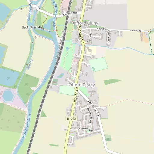
Local Map
⇅
Location Summary
- Offord D'Arcy is a neighbourhood in Offord D'Arcy and Offord Cluny
- Administrative Area: Cambridgeshire
- Ceremonial County: Cambridgeshire
- Historic County: Cambridgeshire
- Region & Country: Eastern / England
⇅
Nearby Towns & Cities
- Parent town: Offord D'Arcy and Offord Cluny
- Godmanchester 4.9 km NNE
- Huntingdon 5.7 km NNE
- St Neots 7.2 km SSW
- St Ives 10.6 km ENE
- Cambridge 24.3 km ESE


⇅
Nearby Localities
- Offord ClunyVillage 841 m N
- Great PaxtonVillage 2.7 km SSW
- BuckdenVillage 3.0 km WNW
- GraveleyVillage 3.8 km SE
- Brampton ParkDistrict 3.9 km NNW
- Belle IsleDistrict 4.0 km NNE
- SouthoeVillage 4.1 km WSW
- ToselandVillage 4.4 km SSE
- BramptonVillage 4.4 km N
- Little PaxtonVillage 4.8 km SW


⇅
Smaller Settlements
- Stirtloe 2.5 km W
- Diddington 2.8 km WSW
- Hardwick 3.1 km NW
- Papworth St Agnes 5.3 km ESE
- Weald 6.6 km S
- Wintringham 6.9 km S
- Ellington Thorpe 7.2 km NW
- Caldecote 8.1 km S
- Duloe 8.4 km SW
- Dillington 8.5 km W


⇅
Beaches
- Snettisham Beach78.4 km NE
- Snettisham Scalp79.3 km NNE
- Stubborn Sand82.2 km NNE

⇅
Parks
- Butt Green24.7 km ESE
- Empty Common25.3 km ESE
- New Pasture6.1 km N
- Wimpole Park18.9 km SE
⇅
Woods
- Coronation Wood3.8 km W
- Lodge Plantation2.9 km W
- Purlieu Spinney2.3 km E
- Toseland Wood3.7 km SSE

⇅
Hills
- Buckden Hill3.0 km W
- Offord Hill2.6 km NNE
- Paxton Hill4.2 km SSW
- Thistle Hill3.7 km NW
⇅
Lakes
- Heronry North Lake3.4 km SW
- Heronry South Lake3.8 km SSW
- Lordship Pond3.8 km SSE
- The Canal2.8 km WNW
⇅
Waterfalls
- Neptune Waterfall71.3 km SSW
- The Cascade61.6 km WSW
- Tower Waterfall71.1 km SSW
⇅
Headlands
- Botany Bay Point100.4 km SSW
- Tripcock Ness88.6 km SSE
⇅
Islands
- Battcock's Island8.0 km NE
- The Island4.9 km NNE
⇅
Wetlands
- Ouse Fen16.9 km ENE
- Gault Hole25.8 km ENE
- Chesterton Fen26.6 km ESE
⇅
Health Services
- Hinchingbrooke HospitalHospital 5.6 km N
- Biggleswade HospitalHospital 20.6 km S
- Henbrook HouseMedical 6.6 km SSW
- Eltisley ManorMedical 6.7 km S
⇅
Education
- Offord Primary SchoolSchool 331 m NNE
- Buckden Church of England Primary SchoolSchool 2.5 km WNW
- Madingley HallUniversity 18.4 km ESE
⇅
Railway Stations
- Huntingdon5.2 km NNE
- St Neots6.0 km SSW
⇅
Bus Stations
- Huntingdon Bus Station5.5 km NNE
- Drummer Street Bus Station24.6 km ESE
⇅
Coach Stations
- Milton Keynes Coachway41.6 km SW
- Luton Airport Bus and Coach Station46.2 km SSW
⇅
Ferry Terminals
- Blackfriars Pier86.2 km S
- Bankside Pier86.5 km S
⇅
Airports
- Cambridge City Airport28.0 km ESE
- London Luton Airport46.3 km SSW
⇅
Airfields
- RAF Alconbury9.1 km N
- RAF Wyton10.6 km NE
⇅
Heliports
- Magpas Air Ambulance10.8 km NNW
- The Egerton-Smith Centre27.6 km ESE
⇅
Harbours
- Chelsea Harbour89.8 km S
- Farndon Harbour96.8 km NNW