
Great Stukeley
About Great Stukeley
Great Stukeley sits within Cambridgeshire. Neighbouring places include Green End only 548 m South East, Owl End only 643 m North North East, Little Stukeley just 1.4 km North West and Stukeley situated 2.1 km South South East. Other countryside places nearby include Alconbury Weald, Wennington, Little Raveley, Woolley and Hardwick.
You may find extra local information by clicking a nearby place.
The place data here is drawn from OS, ONS and OSM under open licence.
⇅
Local Map
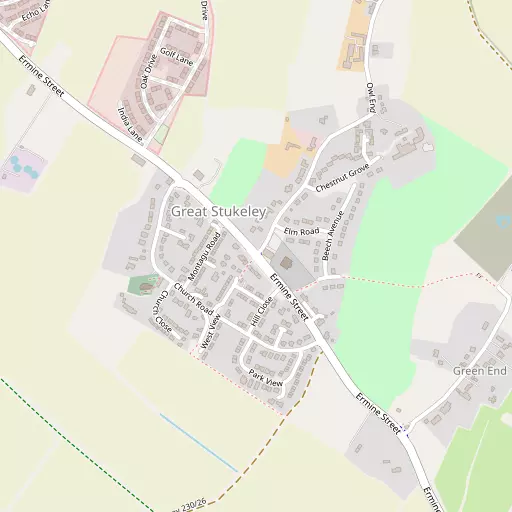
⇅
Location Summary
- Great Stukeley is located in Cambridgeshire
- Administrative Area: Cambridgeshire
- Ceremonial County: Cambridgeshire
- Historic County: Cambridgeshire
- Region & Country: Eastern / England
⇅
Nearby Towns & Cities
- Huntingdon 3.4 km SSE
- Godmanchester 4.8 km SSE
- St Ives 9.9 km ESE
- Ramsey 12.4 km NE
- Peterborough 24.1 km N


⇅
Nearby Localities
- Green EndDistrict 548 m SE
- Owl EndDistrict 643 m NNE
- Little StukeleyVillage 1.4 km NW
- StukeleyDistrict 2.1 km SSE
- SapleyDistrict 2.6 km ESE
- HinchingbrookeDistrict 3.2 km SSE
- Abbots RiptonVillage 3.6 km NNE
- AlconburyVillage 3.6 km WNW
- HartfordDistrict 3.7 km ESE
- NewtownDistrict 3.7 km SE


⇅
Smaller Settlements
- Alconbury Weald 2.1 km NNW
- Wennington 5.1 km NNE
- Little Raveley 6.4 km NE
- Woolley 6.9 km W
- Hardwick 7.0 km SSW
- Ellington Thorpe 7.2 km WSW
- Great Raveley 7.4 km NNE
- Coppingford 7.6 km NW
- Church End 8.0 km N
- Stirtloe 8.1 km SSW


⇅
Beaches
- Snettisham Beach71.7 km NE
- Snettisham Scalp72.5 km NE
- Stubborn Sand75.4 km NE
⇅
Parks
- Butt Green28.3 km SE
- Empty Common29.4 km SE
- New Pasture2.1 km SSE
- Wimpole Park25.8 km SSE
⇅
Woods
- Lodge Spinney2.1 km ENE
- Long Moor Balk1.8 km SSE
- Long Plantation2.4 km S
- Prestley Wood1.4 km NE


⇅
Hills
- Cade's Hill4.2 km NW
- Hartford Hill5.0 km E
- Shipman Hill2.3 km WNW
- Vinegar Hill4.7 km NW

⇅
Lakes
- Cook's Stream4.4 km SE
- Garkie's Mill Lade3.6 km SSE
- Hartford Lake4.9 km ESE
- Old Mill Race4.0 km S
⇅
Waterfalls
- Neptune Waterfall79.1 km SSW
- The Cascade66.0 km WSW
- Tower Waterfall78.9 km SSW
⇅
Headlands
- Botany Bay Point108.3 km SSW
- Tripcock Ness96.5 km SSE
⇅
Islands
- Battcock's Island7.4 km ESE
- The Island4.6 km SSE
⇅
Wetlands
- Ouse Fen15.6 km E
- Gault Hole22.4 km ENE
- Chesterton Fen29.3 km ESE
⇅
Health Services
- Hinchingbrooke HospitalHospital 2.7 km SSE
- Doddington Community HospitalHospital 24.0 km NE
- Primrose Hill Care HomeMedical 3.1 km ESE
- Field LodgeMedical 9.8 km ESE
⇅
Education
- Alconbury Elementary SchoolSchool 774 m NNW
- Alconbury High SchoolSchool 817 m NNW
- Madingley HallUniversity 22.4 km SE
⇅
Railway Stations
- Huntingdon3.4 km SSE
- St Neots14.0 km S
⇅
Bus Stations
- Huntingdon Bus Station3.6 km SSE
- Drummer Street Bus Station28.3 km SE
⇅
Coach Stations
- Milton Keynes Coachway47.2 km SW
- Luton Airport Bus and Coach Station54.3 km SSW

⇅
Ferry Terminals
- Normanton Chain Ferry84.9 km NW
- Blackfriars Pier94.3 km S
⇅
Airports
- Cambridge City Airport31.3 km ESE
- London Luton Airport54.3 km SSW
⇅
Airfields
- RAF Alconbury1.1 km NNW
- RAF Wyton6.5 km E
⇅
Heliports
- Magpas Air Ambulance3.5 km NW
- The Egerton-Smith Centre30.8 km ESE
⇅
Harbours
- Farndon Harbour89.7 km NNW
- Brancaster Harbour90.8 km NE