
Hawridge
About Hawridge
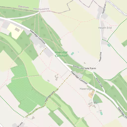
Hawridge sits within Buckinghamshire. Nearby places include Bellingdon lying 1.4 km South, Cholesbury around 1.7 km West North West, Asheridge around 2.1 km South South West, Buckland Common only 2.6 km West North West and Great Hivings only 2.7 km South South East. Other rural places nearby include Heath End, Rossway Park, Griffitts Yard and Hastoe.
You may notice something interesting if you explore one of the nearby places.
This information is based on OS, ONS and OSM data released under open licence.
⇅
Local Map
⇅
Location Summary
- Hawridge is located in Buckinghamshire
- Administrative Area: Buckinghamshire
- Ceremonial County: Buckinghamshire
- Historic County: Buckinghamshire
- Region & Country: South East / England
⇅
Nearby Towns & Cities


⇅
Nearby Localities
- BellingdonVillage 1.4 km S
- CholesburyVillage 1.7 km WNW
- AsheridgeVillage 2.1 km SSW
- Buckland CommonVillage 2.6 km WNW
- Great HivingsDistrict 2.7 km SSE
- ChartridgeVillage 3.0 km SW
- Ashley GreenVillage 3.3 km ESE
- Wigginton Bottom District 3.4 km NNW
- Northchurch District 3.5 km NE
- St LeonardsVillage 3.7 km WNW


⇅
Smaller Settlements
- Heath End 515 m ENE
- Rossway Park 1.6 km NE
- Griffitts Yard 4.2 km SSE
- Hastoe 4.2 km NW
- Norcott Hill 4.3 km NNE
- Swan Bottom 4.6 km WSW
- Chivery 4.8 km WNW
- The Broadway 4.8 km SSE
- Lee Gate 5.0 km W
- West Leith 5.3 km NW


⇅
Beaches
- Bell Wharf Beach91.6 km ESE
- Chapman Sands91.5 km ESE
- Hadleigh Ray87.6 km ESE
⇅
Parks
- Balderson's Moor10.7 km E
- Bell Meadow19.2 km E
- Chaulden Meadow9.0 km E
- Seabrook Meadow18.7 km E
⇅
Woods
- Cheddington Wood1.0 km W
- Hawridge Common453 m NNW
- Hawridge Dean Wood647 m S
- Peppett's Wood780 m WNW
⇅
Hills
- Geary's Hill3.4 km N
- Great Friar's Hill4.0 km S
- Hastoe Hill4.7 km NNW
- Ray's Hill1.6 km WNW

⇅
Lakes
- Bury Pond4.9 km S
- Kingfisher Lake6.5 km SSE
- Rushmoor Pond3.2 km ESE
- Skottowe's Pond4.9 km SSE
⇅
Waterfalls
- Neptune Waterfall9.3 km SSE
- The Cascade40.7 km NW
- Tower Waterfall8.7 km SSE
⇅
Headlands
- Botany Bay Point37.5 km S
- Tripcock Ness56.5 km ESE
⇅
Islands
- Bradbury's Island20.5 km SSE
- Heron Island19.4 km E
⇅
Wetlands
- Cock Marsh20.4 km SSW
- Ickenham Marsh25.4 km SSE
- Wargrave Marsh31.0 km SSW
⇅
Health Services
- The Chiltern HospitalHospital 7.8 km SW
- Amersham HospitalHospital 9.5 km S
- Kilfillan HouseMedical 3.9 km ENE
- Rayners Nursing HomeMedical 6.3 km SSW
⇅
Education
- Hawridge and Cholesbury Church of England SchoolSchool 668 m WNW
- Chartridge Combined SchoolSchool 3.1 km SSW
- Buckinghamshire New UniversityUniversity 14.3 km WNW
⇅
Railway Stations
- Chesham4.8 km SSE
- Berkhamsted4.9 km ENE
⇅
Bus Stations
- Aylesbury Bus Station14.7 km WNW
- High Wycombe Bus Station15.6 km SW
⇅
Coach Stations
- High Wycombe Coachway17.5 km SSW
- Luton Airport Bus and Coach Station22.8 km NE
⇅
Ferry Terminals
- Hammerton's Pier40.0 km SSE
- Hampton Ferry Boathouse41.6 km SSE
⇅
Airports
- Wycombe Air Park19.6 km SW
- London Luton Airport23.2 km NE
⇅
Airfields
- Bovingdon Airfield6.4 km ESE
- Halton Airfield8.8 km WNW
⇅
Heliports
- The London Heliport43.9 km SE
- Magpas Air Ambulance74.7 km NNE

⇅
Harbours
- Chelsea Harbour43.4 km SE
- Cutter's Dock101.8 km ESE