
Holcombe Rogus
About Holcombe Rogus
Holcombe Rogus lies within Devon. Neighbouring places include Westleigh around 1.6 km South, Great Fossend situated 2.2 km South East, Ashbrittle just 2.7 km North North West and White Ball only 3.9 km East. Other rural localities include Whipcott, Hockworthy, Greenham, Tracebridge and Burlescombe.
You may find extra local information by clicking a nearby place.
All information is drawn from OS, ONS and OSM under open licence, reflecting the best available public data.
⇅
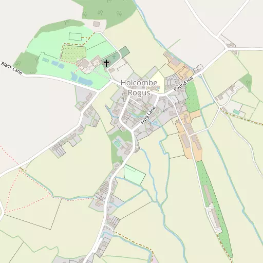
Local Map
⇅
Location Summary
- Holcombe Rogus is located in Devon
- Administrative Area: Devon
- Ceremonial County: Devon
- Historic County: Devon
- Region & Country: South West / England
⇅
Nearby Towns & Cities
- Wellington 8.4 km ENE
- Wiveliscombe 9.4 km NNE
- Tiverton 12.0 km WSW
- Cullompton 12.2 km SSW
- Exeter 29.6 km SSW


⇅
Nearby Localities
- WestleighVillage 1.6 km S
- Great FossendVillage 2.2 km SE
- AshbrittleVillage 2.7 km NNW
- White BallVillage 3.9 km E
- StawleyVillage 4.5 km NNE
- Holywell LakeVillage 5.1 km ENE
- Sampford ArundelVillage 5.1 km E
- Sampford PeverellVillage 5.3 km SSW
- UplowmanVillage 5.5 km SW
- HuntshamVillage 5.9 km WNW


⇅
Smaller Settlements
- Whipcott 1.4 km E
- Hockworthy 2.1 km WNW
- Greenham 2.6 km NE
- Tracebridge 2.6 km NNE
- Burlescombe 2.7 km SE
- Staple Cross 2.8 km WNW
- Appley 3.1 km NNE
- Red Ball 3.5 km ESE
- Ayshford 3.7 km SSW
- Stawley 4.0 km N


⇅
Beaches
- Blue Anchor Beach25.5 km N
- Dunster Beach27.0 km NNW
- West Street Beach24.9 km N
⇅
Parks
- Pennsylvania Park27.7 km SSW
- Pleasure Grounds52.3 km WSW
- The Lawn43.1 km SSW
- Worle Moor52.7 km NNE
⇅
Woods
- Fenton Copse1.1 km N
- Ford Plantation922 m SW
- Holcombe Wood718 m NNW
- The Grove500 m WNW
⇅
Hills
- Beacon Hill1.5 km ENE
- Heniton Hill3.4 km NW
- Knowle Hill1.4 km S
- Rocknell Hill1.8 km S

⇅
Lakes
- Mill Race6.9 km S
- Mill Stream6.5 km S
- Stockingford Water4.0 km NNE
- The Lake5.3 km WNW
⇅
Waterfalls
- Becka Falls48.7 km SW
- Broad Falls65.6 km SW
- Horseshoe Falls59.4 km SW
⇅
Headlands
- Blue Ben26.0 km NNE
- Hurlstone Point34.3 km NNW
⇅
Islands
- Fenning Island36.2 km NE
- Stert Island37.9 km NE
⇅
Wetlands
- New Marsh16.9 km NNE
- Barton Marsh20.9 km WNW
- Swill Point25.4 km N
⇅
Health Services
- Wellington Community HospitalHospital 8.3 km ENE
- Castle Place PracticeHospital 11.9 km WSW
- Oaktree CourtMedical 8.5 km E
- Chelston Park Nursing HomeMedical 9.6 km E
⇅
Education
- Webbers Church of England Primary SchoolSchool 214 m NNE
- Burlescombe Church of England Primary SchoolSchool 2.2 km SE
- Exeter AcademyUniversity 27.6 km SSW
⇅
Railway Stations
- Tiverton Parkway5.0 km SSW
- Bishops Lydeard14.7 km NE
⇅
Bus Stations
- Taunton Bus Station17.7 km ENE
- Exeter Bus Station29.0 km SSW
⇅
Coach Stations
- Torquay Coach Station55.8 km SSW
- Plymouth Coach Station86.3 km SW
⇅
Ferry Terminals
- Starcross Pier37.8 km S
- Greenway Quay66.6 km SSW
⇅
Airports
- Exeter Airport25.5 km S
- Cardiff Airport48.7 km N
⇅
Airfields
- Dunkeswell Airfield13.3 km SE
- Watchford Farm18.4 km ESE
⇅
Heliports
- Cardiff City Heliport58.2 km NNE
- Lake Heliport64.1 km W

⇅
Harbours
- Watchet Harbour24.8 km N
- Lympstone Boat Shelter35.3 km S