
Uplowman
About Uplowman
Uplowman is in Devon. Among the nearby places are Sampford Peverell lying 1.5 km East South East, Halberton just 2.6 km South South West, Ash Thomas just 4.1 km South South West and Westleigh around 4.8 km East North East. Other nearby hamlets and settlements include Whitnage, East Mere, Craze Lowman, Ayshford and Chevithorne.
You might discover something new by clicking a nearby place for more local details.
Information is sourced from OS, ONS and OSM under open licence, using publicly available datasets.
⇅
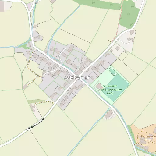
Local Map
⇅
Location Summary
- Uplowman is located in Devon
- Administrative Area: Devon
- Ceremonial County: Devon
- Historic County: Devon
- Region & Country: South West / England
⇅
Nearby Towns & Cities
- Tiverton 6.7 km WSW
- Cullompton 8.0 km S
- Wellington 13.5 km ENE
- Wiveliscombe 14.2 km NNE
- Exeter 24.5 km SSW


⇅
Nearby Localities
- Sampford PeverellVillage 1.5 km ESE
- HalbertonVillage 2.6 km SSW
- Ash ThomasVillage 4.1 km SSW
- WestleighVillage 4.8 km ENE
- WillandVillage 5.1 km SSE
- Moorhayes ParkDistrict 5.2 km WSW
- HuntshamVillage 5.4 km NNW
- Holcombe RogusVillage 5.5 km NE
- UffculmeVillage 5.7 km ESE
- Great FossendVillage 5.8 km ENE


⇅
Smaller Settlements
- Whitnage 1.3 km ENE
- East Mere 2.1 km WNW
- Craze Lowman 3.2 km WSW
- Ayshford 3.2 km E
- Chevithorne 4.1 km W
- Brithem Bottom 4.9 km S
- Hockworthy 4.9 km NNE
- Chettiscombe 5.0 km W
- Appledore 5.2 km E
- Staple Cross 5.3 km NNE


⇅
Beaches
- Blue Anchor Beach28.9 km N
- Sidmouth Town Beach30.0 km SSE
- West Street Beach29.0 km N

⇅
Parks
- Pennsylvania Park22.7 km SSW
- Pleasure Grounds46.9 km WSW
- The Lawn38.8 km S
- The Warren56.7 km NW

⇅
Woods
- Bradford Copse2.3 km WSW
- Lee Ditch Copse2.6 km NE
- Lower Plantation2.3 km NNE
- Radley Copse2.1 km W
⇅
Hills
- Buddle Hill1.2 km ENE
- Connigar Hill1.3 km ESE
- Huntland Hill2.9 km E
- Paullet Hill720 m ESE
⇅
Lakes
- Allers Ponds4.9 km W
- Mill Pond4.9 km SE
- Mill Race5.0 km SE
- Mill Stream5.6 km ESE

⇅
Waterfalls
- Becka Falls43.3 km SW
- Broad Falls60.2 km SW
- Horseshoe Falls54.0 km SSW

⇅
Headlands
- Blue Ben30.7 km NNE
- Brandy Head32.7 km SSE
⇅
Islands
- Fenning Island41.6 km NE
- Stert Island43.4 km NE
⇅
Wetlands
- Barton Marsh19.0 km NW
- New Marsh22.0 km NNE
- Duck's Marsh25.8 km SSW
⇅
Health Services
- Castle Place PracticeHospital 6.7 km WSW
- Wellington Community HospitalHospital 13.4 km ENE
- Orchard LeaMedical 8.3 km S
- Castle Grove Residential HomeMedical 9.3 km NW
⇅
Education
- Uplowman Church of England Primary SchoolSchool 452 m NNE
- Sampford Peverell Church of England Primary SchoolSchool 1.5 km SE
- Exeter AcademyUniversity 22.6 km SSW
⇅
Railway Stations
- Tiverton Parkway3.1 km ESE
- Feniton17.7 km SSE
⇅
Bus Stations
- Taunton Bus Station22.9 km ENE
- Exeter Bus Station24.0 km SSW
⇅
Coach Stations
- Torquay Coach Station51.3 km S
- Plymouth Coach Station80.8 km SW
⇅
Ferry Terminals
- Starcross Pier33.5 km S
- Greenway Quay62.0 km SSW
⇅
Airports
- Exeter Airport21.4 km S
- Cardiff Airport52.6 km N
⇅
Airfields
- Dunkeswell Airfield13.8 km ESE
- Watchford Farm21.5 km E
⇅
Heliports
- Lake Heliport60.6 km WNW
- Cardiff City Heliport62.8 km NNE
⇅
Harbours
- Watchet Harbour28.9 km N
- Lympstone Boat Shelter31.1 km S