
Ipplepen
About Ipplepen
Ipplepen, in Devon, has Denbury only 2.6 km North West, Abbotskerswell around 2.9 km North East, East Ogwell around 3.4 km North, Broadhempston situated 3.6 km West and Compton around 3.9 km East South East. Other countryside places nearby include Torbryan, Dainton, Two Mile Oak Cross and North Whilborough.
You may find extra local information by clicking a nearby place.
This information is based on OS, ONS and OSM data released under open licence.
⇅
Local Map
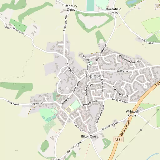
⇅
Location Summary
- Ipplepen is located in Devon
- Administrative Area: Devon
- Ceremonial County: Devon
- Historic County: Devon
- Region & Country: South West / England
⇅
Nearby Towns & Cities
- Newton Abbot
- Totnes
- Kingsteignton
- Paignton
- Exeter
⇅
Nearby Localities
⇅
Smaller Settlements
⇅
Beaches
- Hollicombe Beach
- Livermead Sands
- Preston Sands
⇅
Parks
- Palm Cross Green
- Pennsylvania Park
- Pleasure Grounds
- The Lawn
⇅
Woods
- Blackrock Copse
- Clennonpark Wood
- Lidmore Copse
- Orley Common
⇅
Hills
- Blair Hill
- Holman Hill
- Moretons Hill
- Wrigwell Hill
⇅
Lakes
- Aptor Pool
- Bickley Pond
- Upper Lake
- Zitherixon Clay Works
⇅
Waterfalls
- Becka Falls
- Broad Falls
- Horseshoe Falls
⇅
Headlands
- Sharpham Point
- Watcombe Head
⇅
Islands
- Dartington Island
- Snipe Island
⇅
Wetlands
- Hackney Marshes
- Buckland Point
- Netherton Point
⇅
Health Services
- Newton Abbot Community Hospital
- Torbay Hospital Annexe
- Bramble Down
- Mount Olivet Nursing Home
⇅
Education
- Ipplepen Primary School
- Denbury Primary School
- South Devon College Brunel Centre
⇅
Train Stations
- Newton Abbot
- Staverton
⇅
Bus Stations
- Kingsbridge Bus Station
- Exeter Bus Station
⇅
Coach Stations
- Torquay Coach Station
- Plymouth Coach Station
⇅
Ferry Terminals
- Greenway Quay
- Kingswear Hoodown
⇅
Airports
- Exeter Airport
- Plymouth City Airport
⇅
Airfields
- Bolt Head Airfield
⇅
Heliports
- Lake Heliport
⇅
Harbours
- Paignton Harbour
- New Harbour