
Little Harrowden
About Little Harrowden
Little Harrowden, in North Northamptonshire, has Orlingbury lying 1.2 km North West, Great Harrowden around 1.3 km East South East, Hardwick around 2.5 km South West and Isham around 2.7 km North North East. Other rural places nearby include Hill Top, Knuston, Farndish, Orton and Strixton.
You may notice something interesting if you explore one of the nearby places.
This page uses OS, ONS and OSM data supplied under open licence.
⇅
Local Map
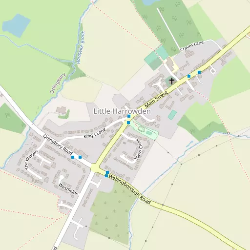
⇅
Location Summary
- Little Harrowden is located in North Northamptonshire
- Administrative Area: North Northamptonshire
- Ceremonial County: North Northamptonshire
- Historic County: North Northamptonshire
- Region & Country: East Midlands / England
⇅
Nearby Towns & Cities
- Wellingborough 4.3 km SSE
- Burton Latimer 4.4 km NE
- Kettering 7.3 km N
- Irthlingborough 7.7 km E
- Milton Keynes 32.5 km S


⇅
Nearby Localities
- OrlingburyVillage 1.2 km NW
- Great HarrowdenVillage 1.3 km ESE
- HardwickVillage 2.5 km SW
- IshamVillage 2.7 km NNE
- Hatton ParkDistrict 3.3 km SSE
- PytchleyVillage 3.4 km NNW
- Burrow's BushDistrict 3.6 km SE
- FinedonVillage 4.9 km E
- WilbyVillage 5.3 km S
- BroughtonVillage 5.5 km NW


⇅
Smaller Settlements


⇅
Beaches
- Snettisham Beach98.5 km NE
- Snettisham Scalp98.9 km NE
- Stubborn Sand101.5 km NE
⇅
Parks
- Buckwell Green3.8 km SSE
- Foot Meadow16.6 km SW
- The Green21.0 km SW
- The Green29.8 km S
⇅
Woods
- Big Covert1.5 km NNE
- Lammas Spinney727 m NNW
- Lodge Covert1.6 km E
- Roadside Spinney770 m WNW

⇅
Hills
- Beacon Hill9.4 km SSE
- Crow Hill8.3 km E
- Red Hill1.4 km SE
- Woodford Hill10.3 km NE
⇅
Lakes
- Cransley Reservoir7.8 km NNW
- Park Pond6.4 km SW
- Skew Bridge Ski Lake7.6 km ESE
- Sywell Reservoir7.2 km SW
⇅
Waterfalls
- Neptune Waterfall74.0 km S
- The Cascade39.5 km SSW
- Tower Waterfall73.5 km S
⇅
Headlands
- Botany Bay Point103.0 km S
- Tripcock Ness107.6 km SSE
⇅
Islands
- Heron Island16.9 km SSE
- Millholme Island17.6 km SSE
⇅
Wetlands
- Summer Leys8.0 km S
- Lucas Marsh37.5 km NW
- West Marsh42.1 km NNE
⇅
Health Services
- Isebrook HospitalHospital 5.0 km SE
- St Mary's HospitalHospital 6.6 km N
- Park House Nursing HomeMedical 3.9 km SSE
- Kenroyal Nursing HomeMedical 4.3 km SSE
⇅
Education
- Little Harrowden Community Primary SchoolSchool 314 m NNE
- Glenvale Primary SchoolSchool 1.7 km SSE
- Wellingborough CampusUniversity 4.1 km SSE
⇅
Railway Stations
- Wellingborough4.9 km SE
- Kettering6.5 km N
⇅
Bus Stations
- North Gate Bus Station15.9 km SW
- Daventry Bus Station30.9 km WSW

⇅
Coach Stations
- Milton Keynes Coachway31.1 km S
- Luton Airport Bus and Coach Station56.0 km SSE
⇅
Ferry Terminals
- Normanton Chain Ferry62.1 km NNW
- Embankment Pier100.9 km SSE
⇅
Airports
- Coventry Airport51.6 km W
- London Luton Airport56.5 km SSE

⇅
Airfields
- Sywell Aerodrome5.6 km SW
- Sackfield Airfield18.2 km ESE
⇅
Heliports
- Magpas Air Ambulance32.7 km E
- Nottingham Heliport59.8 km NNW
⇅
Harbours
- Farndon Harbour81.5 km N
- Chelsea Harbour102.6 km SSE