
Newnham, Burwell
About Newnham
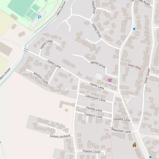
Newnham is 642 m SSE from Burwell in the county of Cambridgeshire. Neighbouring places include Burwell around 642 m South South East, Old Pembroke Farm lying 1.3 km South South East, Reach around 2.3 km West South West and Swaffham Prior just 3.4 km South South West. Other local places include Landwade, Upware, River Bank, Barcham Corner and Clayhithe.
You may find out something new or interesting if you click a nearby place to see more local information.
Data shown here comes from OS, ONS and OSM under open licence, using the latest public sources available.
⇅
Local Map
⇅
Location Summary
- Newnham is a neighbourhood in Burwell
- Administrative Area: Cambridgeshire
- Ceremonial County: Cambridgeshire
- Historic County: Cambridgeshire
- Region & Country: Eastern / England
⇅
Nearby Towns & Cities


⇅
Nearby Localities
- BurwellVillage 642 m SSE
- Old Pembroke FarmDistrict 1.3 km SSE
- ReachVillage 2.3 km WSW
- Swaffham PriorVillage 3.4 km SSW
- Exning Village 3.6 km ESE
- WickenVillage 3.8 km NNW
- Commercial EndVillage 5.0 km SW
- Studlands Park District 5.1 km ESE
- Down FieldVillage 5.1 km NNE
- Swaffham BulbeckVillage 5.7 km SSW


⇅
Smaller Settlements
- Landwade 3.8 km E
- Upware 5.6 km WNW
- River Bank 5.6 km WNW
- Barcham Corner 8.7 km N
- Clayhithe 8.8 km WSW
- Chittering 9.1 km WNW
- Barway 9.4 km NNW
- Broad Hill 9.5 km N
- Westley Bottom 9.8 km S
- Badlingham 9.8 km ENE


⇅
Other places with this name
- Newnham, Cambridgeshire17.4 km WSW
- Newnham, Hertfordshire 45.2 km SW
- Newnham, West Northamptonshire100.7 km W
- Newnham, Kent 115.5 km SSE
- Newnham, Warwickshire 142.5 km W
- Newnham, Hampshire 143.2 km SW
- Newnham, Gloucestershire 196.9 km WSW

⇅
Beaches
- Mill Beach66.8 km SSE
- Snettisham Beach65.3 km N
- Snettisham Scalp66.6 km N
⇅
Parks
- Butt Green15.5 km WSW
- Empty Common16.7 km SW
- Pound Green28.5 km ESE
- Risbridge Meadow23.4 km SSE
⇅
Woods
- Priory Wood773 m SSW
- St Edmund's Fen3.5 km NNW
- Warbraham Wood3.4 km SSE
- Wicken Poors' Fen3.8 km NW

⇅
Hills
- Bunkers Hill953 m SSE
- Church Hill2.8 km SW
- Middle Hill5.5 km SSW
- Pound Hill702 m SE
⇅
Lakes
- Brook Dam5.8 km NNE
- Four Ponds5.5 km E
- The Canal8.0 km ENE
- Todd's Pond9.7 km SSE
⇅
Waterfalls
- Neptune Waterfall90.1 km SW
- The Cascade95.5 km WSW
- Tower Waterfall90.3 km SW
⇅
Headlands
- North Weir Point82.2 km ESE
- Tripcock Ness87.2 km S
⇅
Islands
- Riddy Island21.1 km SW
- The Island17.7 km SSE
⇅
Wetlands
- The Marsh4.4 km SE
- Chesterton Fen12.0 km WSW
- Gault Hole20.0 km NW
⇅
Health Services
- Newmarket HospitalHospital 6.2 km ESE
- Ida Darwin HospitalHospital 13.3 km SW
- Waterhouse Manor Care HomeMedical 5.2 km NE
- Brampton ManorMedical 6.4 km ESE

⇅
Education
- Burwell Village College Primary SchoolSchool 391 m ESE
- Exning Primary SchoolSchool 3.5 km ESE
- College of West AngliaUniversity 11.0 km WSW
⇅
Railway Stations
- Soham6.0 km N
- Newmarket7.4 km SE
⇅
Bus Stations
- Mildenhall Bus Station14.7 km ENE
- Drummer Street Bus Station15.9 km WSW
⇅
Coach Stations
- Stansted Airport Coach Station43.7 km S
- Luton Airport Bus and Coach Station65.3 km SW
⇅
Ferry Terminals
- Harwich Ferry Port73.5 km ESE
- Burnham Ferry80.5 km SSE
⇅
Airports
- Cambridge City Airport13.2 km SW
- Stansted Airport44.1 km S
⇅
Airfields
- RAF Mildenhall14.5 km NE
- Lakenheath Airfield21.1 km NE
⇅
Heliports
- The Egerton-Smith Centre13.2 km SW
- Magpas Air Ambulance40.3 km WNW
⇅
Harbours
- Harwich Harbour75.7 km ESE
- Brancaster Harbour81.0 km NNE