
Pool
About Pool
Pool, in Cornwall, has Illogan Highway only 829 m East North East, Tuckingmill around 1.0 km South West, Tolskithy around 1.1 km East North East, Tolvaddon situated 1.2 km West North West and Brea just 1.4 km South South West. Other places in the surrounding countryside include Penhallick, Piece, Tolgus Mount and Roscroggan.
You might learn something new by clicking through to a nearby place.
This information is based on OS, ONS and OSM data released under open licence.
⇅
Local Map
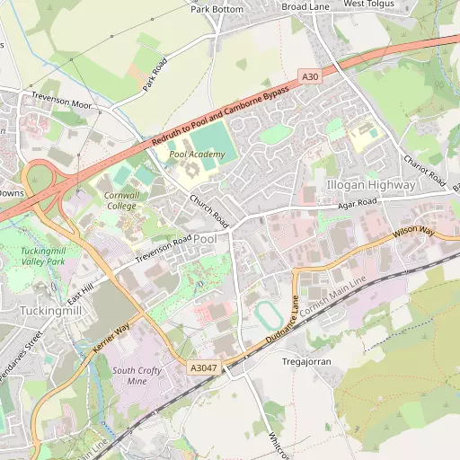
⇅
Location Summary
- Pool is located in Cornwall
- Administrative Area: Cornwall
- Ceremonial County: Cornwall
- Historic County: Cornwall
- Region & Country: South West / England
⇅
Nearby Towns & Cities


⇅
Nearby Localities
- Illogan HighwayVillage 829 m ENE
- TuckingmillDistrict 1.0 km SW
- TolskithyDistrict 1.1 km ENE
- TolvaddonVillage 1.2 km WNW
- BreaVillage 1.4 km SSW
- IlloganVillage 1.6 km NNE
- BlowinghouseDistrict 1.6 km E
- West TolgusDistrict 1.8 km NE
- Carn Brea VillageVillage 1.9 km E
- PengegonDistrict 1.9 km SSW


⇅
Smaller Settlements
- Penhallick 768 m S
- Piece 1.9 km SE
- Tolgus Mount 2.0 km NE
- Roscroggan 2.1 km WNW
- Treskillard 2.4 km SSE
- Sparnon Gate 2.7 km NE
- Gilbert's Coombe 3.1 km NE
- Reskadinnick 3.4 km W
- Bolenowe 3.6 km S
- Cambrose 4.2 km NNE


⇅
Other places with this name
- Pool, Devon97.5 km ENE
⇅
Beaches
- Gwithian Beach9.0 km W
- Porthtowan Beach6.9 km NNE
- Portreath Beach4.3 km NNW

⇅
Parks
- Lanner Moor5.4 km ESE
- Palm Cross Green98.9 km E
- Summerleaze Down84.5 km NE
- Trungle Moor25.3 km SW
⇅
Woods
- Beech Wood3.0 km WNW
- Illogan Woods3.3 km NNW
- Magor Plantation3.0 km WNW
- Oak Wood3.4 km WNW
⇅
Hills
- Carn Brea1.6 km ESE
- Carn Marth4.6 km E
- North Downs4.9 km NE
- Western Hill4.5 km NNW
⇅
Lakes
- Boswyn Reservoir5.3 km S
- Cargenwen Reservoirs6.4 km S
- House of Water1.7 km ESE
- Stithians Reservoir6.5 km SE
⇅
Waterfalls
- Golitha Falls61.5 km ENE
- White Lady Waterfall92.9 km ENE
- Yealm Steps97.1 km ENE
⇅
Headlands
- Godrevy Point8.9 km W
- Gooden Heane Point4.7 km NNW
⇅
Islands
- Godrevy Island9.6 km W
- St Michael's Mount19.3 km SW
⇅
Wetlands
- Copperhouse Pool11.1 km WSW
- Bamaluz Point14.7 km W
- Weir Point15.6 km ESE
⇅
Health Services
- Camborne Redruth Community HospitalHospital 1.7 km E
- St Michael's HospitalHospital 12.2 km WSW
- FairholmeMedical 1.7 km SW
- The GreenMedical 3.1 km ENE
⇅
Education
- Pool AcademySchool 422 m NNW
- Cornwall College of Further and Higher EducationSchool 586 m WNW
- Cornwall College of Further and Higher EducationUniversity 586 m WNW
⇅
Railway Stations
- Camborne2.8 km SW
- Redruth3.1 km ENE
⇅
Bus Stations
- Camborne Bus Station2.6 km SW
- St Ives15.0 km W
⇅
Coach Stations
- Plymouth Coach Station81.5 km ENE
- Torquay Coach Station125.9 km ENE
⇅
Ferry Terminals
- Trelissick17.1 km E
- Philleigh17.4 km E
⇅
Airports
- Newquay Cornwall Airport29.8 km NE
- Land's End Airport31.9 km WSW
⇅
Airfields
- Truro Airfield10.6 km ENE
- Perranporth Airfield13.1 km NNE
⇅
Heliports
- Penzance Heliport20.5 km WSW
- Cornwall Air Ambulance Station30.5 km NE
⇅
Harbours
- South Harbour13.9 km ESE
- Penryn Harbour14.5 km ESE