
Sidmouth
About Sidmouth
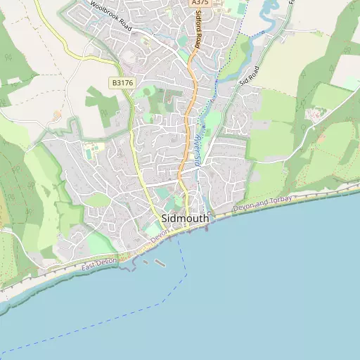
Sidmouth, in Devon, has New Town situated 177 m East, Eastern Town situated 364 m South South East, Western Town only 457 m South South West and Cotmaton lying 814 m West South West. Other rural places nearby include Stowford, Salcombe Regis, Trow, Weston and Harcombe.
You may find out something new or interesting if you click a nearby place to see more local information.
The details shown here use OS, ONS and OSM data provided under open licence.
⇅
Local Map
⇅
Location Summary
- Sidmouth is located in Devon
- Administrative Area: Devon
- Ceremonial County: Devon
- Historic County: Devon
- Region & Country: South West / England
⇅
Nearby Towns & Cities
- Ottery St Mary 8.2 km NNW
- Budleigh Salterton 8.6 km SW
- Seaton 12.0 km ENE
- Colyton 13.5 km ENE
- Exeter 21.2 km WNW


⇅
Nearby Localities
- New TownDistrict 177 m E
- Eastern TownDistrict 364 m SSE
- Western TownDistrict 457 m SSW
- CotmatonDistrict 814 m WSW
- SidDistrict 932 m NNE
- BulvertonDistrict 1.4 km NW
- Lower WoolbrookDistrict 1.4 km N
- Middle WoolbrookDistrict 1.6 km NNW
- FortescueDistrict 1.7 km NE
- Higher WoolbrookDistrict 1.9 km NNW


⇅
Smaller Settlements
- Stowford 2.3 km NNW
- Salcombe Regis 2.5 km ENE
- Trow 3.3 km ENE
- Weston 3.9 km ENE
- Harcombe 4.1 km NE
- Cotford 4.8 km NNE
- Coombe 5.0 km NNW
- Southerton 5.7 km WNW
- Venn Ottery 5.8 km NW
- Stowford 6.6 km W

⇅
Beaches
- Chiselbury Beach4.6 km SW
- Jacob's Ladder1.9 km SW
- Sidmouth Town Beach578 m SSW
⇅
Parks
- Palm Cross Green59.1 km SW
- Pennsylvania Park20.9 km WNW
- Pleasure Grounds53.7 km W
- The Lawn19.8 km SW
⇅
Woods
- Brachers Hill Plantation1.5 km WSW
- Greystone Hill Plantations1.5 km W
- Hart's Holes Plantation1.9 km WNW
- Lyde's Hill Plantation1.7 km W
⇅
Hills
- Peak Hill1.9 km WSW
- Salcombe Hill1.8 km ENE
- Soldier's Hill2.2 km NE
- Wheat Hill1.2 km NW
⇅
Lakes
- Mill Stream5.1 km WSW
- Paccombe Pond3.9 km ENE
- The Lake5.8 km WSW
- Woodbrook Reservoir1.3 km NNW
⇅
Waterfalls
- Becka Falls37.2 km WSW
- Broad Falls51.5 km WSW
- Horseshoe Falls44.9 km WSW
⇅
Headlands
- Brandy Head5.8 km SW
- Otterton Point7.5 km SW
⇅
Islands
- Ore Stone29.9 km SSW
- Thatcher Rock30.8 km SW
⇅
Wetlands
- Weston Ebb4.9 km E
- Beer Head10.0 km E
- Stafford Marsh13.1 km ENE
⇅
Health Services
- Sidmouth Victoria HospitalHospital 131 m SW
- SeachangeHospital 8.0 km SW
- Sidmouth Nursing HomeMedical 1.0 km NNW
- Vale View HeightsMedical 2.2 km NE
⇅
Education
- Sidmouth Church of England Primary SchoolSchool 265 m NNE
- St John's SchoolSchool 918 m WNW
- RowancroftUniversity 19.6 km WNW
⇅
Railway Stations
- Feniton12.0 km NNW
- Seaton Tramway12.3 km ENE
⇅
Bus Stations
- Exeter Bus Station20.7 km WNW
- Taunton Bus Station38.2 km NNE
⇅
Coach Stations
- Torquay Coach Station31.3 km SW
- Plymouth Coach Station72.7 km WSW
⇅
Ferry Terminals
- Starcross Pier15.9 km WSW
- Greenway Quay41.7 km SW
⇅
Airports
- Exeter Airport13.6 km WNW
- Plymouth City Airport67.9 km WSW
⇅
Airfields
- Farway Common Airfield7.3 km NE
- Dunkeswell Airfield20.1 km N
⇅
Heliports
- Lake Heliport81.1 km WNW
- Cardiff City Heliport87.6 km N
⇅
Harbours
- Lympstone Boat Shelter14.2 km WSW
- Old Harbour31.9 km SW