
St Columb Minor, Newquay
About St Columb Minor
St Columb Minor sits 637 m S of Newquay in Cornwall. Local places nearby include Nansledan just 637 m South, Porth around 964 m West North West, Whipsiderry around 1.2 km North West and Lane around 2.1 km South South West. Other settlements close by include Colan, Kestle Mill, Trevemper, Mountjoy and Trebudannon.
You may find extra local information by clicking a nearby place.
Information is sourced from OS, ONS and OSM under open licence, using publicly available datasets.
⇅
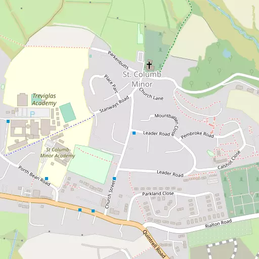
Local Map
⇅
Location Summary
- St Columb Minor is a neighbourhood in Newquay
- Administrative Area: Cornwall
- Ceremonial County: Cornwall
- Historic County: Cornwall
- Region & Country: South West / England
⇅
Nearby Towns & Cities
- Parent town: Newquay
- Newquay 2.8 km WSW
- St Columb Major 7.5 km ENE
- Padstow 15.4 km NNE
- Wadebridge 18.2 km NE
- Truro 17.4 km S


⇅
Nearby Localities
- NansledanDistrict 637 m S
- PorthDistrict 964 m WNW
- WhipsiderryDistrict 1.2 km NW
- LaneVillage 2.1 km SSW
- Quintrell DownsVillage 2.2 km SSE
- TreninnickDistrict 2.4 km SW
- TrenanceDistrict 2.5 km WSW
- TregurrianVillage 3.3 km NNE
- TrevarrianVillage 4.2 km NNE
- PentireDistrict 4.4 km WSW


⇅
Smaller Settlements
- Colan 3.1 km ESE
- Kestle Mill 3.2 km SSE
- Trevemper 3.2 km SW
- Mountjoy 3.8 km ESE
- Trebudannon 5.5 km E
- White Cross 5.7 km ESE
- Treworgans 6.2 km SW
- West Pentire 6.4 km WSW
- Tredinnick 6.4 km SSE
- Tresean 6.6 km SW


⇅
Beaches
- Lusty Glaze1.6 km W
- Porth Beach1.3 km WNW
- Whipsiderry Beach1.5 km NW

⇅
Parks
- Lanner Moor25.1 km SSW
- Pleasure Grounds81.8 km ENE
- Summerleaze Down57.8 km NE
- Trungle Moor51.5 km SW
⇅
Woods
- Carnanton Woods5.3 km ENE
- Firhill Wood3.9 km E
- Menadews Plantation6.7 km ENE
- Metha Wood5.9 km S
⇅
Hills
- Belowda Beacon13.2 km E
- St Breock Beacon14.2 km ENE
- Trendeal Hill10.5 km SSE
- Zelah Hill10.0 km SSW
⇅
Lakes
- Porth Reservoir2.9 km E
- Ruthvoes Reservoir9.2 km E
- Trenance Boating Lake2.7 km WSW
- Tresaddern Water8.9 km E
⇅
Waterfalls
- Golitha Falls38.9 km ENE
- White Lady Waterfall69.3 km ENE
- Yealm Steps77.6 km E
⇅
Headlands
- Creepinghole Point2.1 km N
- Trevelgue Head1.7 km WNW

⇅
Islands
- Porth Island1.6 km WNW
- Zacry's Islands1.8 km NNW

⇅
Wetlands
- Sunny Corner3.9 km W
- Stem Point4.0 km N
- Grange Point5.3 km N
⇅
Health Services
- Newquay HospitalHospital 2.4 km WSW
- Treliske HospitalHospital 17.4 km SSW
- Newquay Nursing and Residential HomeMedical 4.5 km WSW
- St MargaretsMedical 8.4 km ESE
⇅
Education
- St Columb Minor AcademySchool 232 m WSW
- Treviglas Community CollegeSchool 327 m WNW
- Cornwall CollegeUniversity 1.9 km WSW
⇅
Railway Stations
- Quintrell Downs2.0 km SSE
- Newquay2.3 km WSW
⇅
Bus Stations
- Newquay Bus Station3.1 km WSW
- Truro Bus Station17.5 km S
⇅
Coach Stations
- Plymouth Coach Station64.0 km E
- Torquay Coach Station106.9 km E
⇅
Ferry Terminals
- Trelissick22.6 km S
- Philleigh22.6 km S
⇅
Airports
- Newquay Cornwall Airport3.1 km NE
- Land's End Airport56.9 km SW
⇅
Airfields
- St Merryn Airfield10.5 km NNE
- Perranporth Airfield13.9 km SW
⇅
Heliports
- Cornwall Air Ambulance Station4.5 km ENE
- Penzance Heliport46.3 km SW
⇅
Harbours
- Charlestown Docks22.6 km ESE
- Mevagissey Harbour24.8 km SE
