
Stockland Bristol
About Stockland Bristol
Stockland Bristol sits within Somerset. Places nearby include Combwich around 2.2 km East South East, Stogursey lying 3.6 km West, Fiddington around 3.7 km South West, Shurton only 3.9 km West and Cannington only 4.4 km South South East. Other rural places nearby include Otterhampton, Cockwood, Coultings and Stolford.
You may find extra local information by clicking a nearby place.
All place information is taken from OS, ONS and OSM under open licence.
⇅
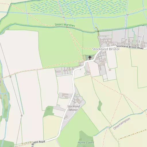
Local Map
⇅
Location Summary
- Stockland Bristol is located in Somerset
- Administrative Area: Somerset
- Ceremonial County: Somerset
- Historic County: Somerset
- Region & Country: South West / England
⇅
Nearby Towns & Cities
- Bridgwater 8.7 km SE
- Burnham-on-Sea 8.9 km NE
- North Petherton 11.7 km SSE
- Watchet 16.8 km W
- Wells 31.0 km E


⇅
Nearby Localities
- CombwichVillage 2.2 km ESE
- StogurseyVillage 3.6 km W
- FiddingtonVillage 3.7 km SW
- ShurtonVillage 3.9 km W
- CanningtonVillage 4.4 km SSE
- Nether StoweyVillage 6.0 km SW
- PawlettVillage 6.2 km E
- Four ForksVillage 6.5 km S
- SpaxtonVillage 6.6 km S
- Chilton TrinityVillage 7.2 km SE


⇅
Smaller Settlements


⇅
Beaches
- Berrow Beach9.7 km NNE
- Brean Beach13.9 km NNE
- Burnham-on-Sea Beach9.1 km NE

⇅
Parks
- Castle Green33.6 km N
- Splott Park33.5 km N
- Worle Moor22.1 km NNE
- Yargrass Green29.5 km E

⇅
Woods
- Home Covert490 m S
- Lodge Wood883 m SSE
- New Barn Wood819 m SW
- Robbery Wood1.0 km S
⇅
Hills
- Bower Hill3.9 km S
- Pawlett Hill5.1 km E
- Pinnacle Hill4.9 km SW
- Tet Hill4.0 km WSW
⇅
Lakes
- Ashford Reservoir5.1 km S
- Brambles Pit5.3 km W
- Cannington Park Quarry3.3 km SSE
- Culls Pit6.0 km WSW
⇅
Waterfalls
- Berw-ddu64.7 km NNW
- Llech Sychryd68.4 km NNW
- Pwll Annie67.5 km NNW
⇅
Headlands
- Blue Ben11.6 km W
- Stert Point6.0 km NE
⇅
Islands
- Fenning Island5.8 km NE
- Stert Island7.3 km NE
⇅
Wetlands
- Goose Marsh2.6 km NNW
- Streart Marshes3.2 km ENE
- Marchant's Sands4.5 km ESE

⇅
Health Services
- War Memorial HospitalHospital 8.9 km NE
- Broadway HouseHospital 9.2 km SE
- The Rosary Nursing HomeMedical 8.0 km SSE
- Southwood HouseMedical 9.0 km SE
⇅
Education
- Otterhampton Primary SchoolSchool 2.1 km ESE
- Bridgwater and Taunton College Cannington CentreSchool 4.0 km SSE
- Weston College South West Skills CampusUniversity 20.8 km NNE
⇅
Railway Stations
- Highbridge and Burnham9.0 km ENE
- Bridgwater9.5 km SE
⇅
Bus Stations
- Taunton Bus Station19.0 km S
- Cardiff Bus Interchange32.9 km N
⇅
Coach Stations
- Torquay Coach Station85.1 km SSW
- Millstream Coach Park91.1 km E
⇅
Ferry Terminals
- Newport Transporter Bridge East43.4 km N
- Newport Transporter Bridge West43.4 km N
⇅
Airports
- Cardiff Airport29.6 km NW
- Bristol Airport33.9 km NE

⇅
Airfields
- Westonzoyland15.3 km SE
- Halesland Airfield26.2 km ENE
⇅
Heliports
- Cardiff City Heliport31.5 km N
- Lake Heliport82.8 km WSW
⇅
Harbours
- Watchet Harbour16.6 km W
- Mud Dock45.1 km NE