
Stogursey
About Stogursey
Stogursey, in Somerset, has Shurton lying 1.2 km North North West, Fiddington situated 2.7 km South South East, Nether Stowey just 3.4 km South South West and Stockland Bristol around 3.6 km East. Other places in the surrounding countryside include Burton, Cockwood, Knighton, Durborough and Wick.
You might discover something new by clicking a nearby place for more local details.
This information is based on OS, ONS and OSM data released under open licence.
⇅
Local Map
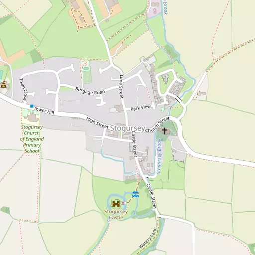
⇅
Location Summary
- Stogursey is located in Somerset
- Administrative Area: Somerset
- Ceremonial County: Somerset
- Historic County: Somerset
- Region & Country: South West / England
⇅
Nearby Towns & Cities
- Bridgwater 11.0 km ESE
- Burnham-on-Sea 12.1 km ENE
- North Petherton 13.1 km SE
- Watchet 13.2 km W
- Cardiff 33.5 km N


⇅
Nearby Localities
- ShurtonVillage 1.2 km NNW
- FiddingtonVillage 2.7 km SSE
- Nether StoweyVillage 3.4 km SSW
- Stockland BristolVillage 3.6 km E
- HolfordVillage 5.2 km WSW
- KilveVillage 5.4 km W
- CombwichVillage 5.5 km E
- SpaxtonVillage 6.3 km SSE
- CanningtonVillage 6.4 km ESE
- Four ForksVillage 6.5 km SSE


⇅
Smaller Settlements
- Burton 1.4 km NW
- Cockwood 1.6 km E
- Knighton 1.8 km NW
- Durborough 1.9 km SW
- Wick 2.1 km NE
- Stringston 2.8 km W
- Coultings 2.8 km ESE
- Bonson 3.0 km SE
- Stolford 3.7 km NE
- Dyche 3.8 km WSW


⇅
Beaches
- Berrow Beach12.0 km NE
- Burnham-on-Sea Beach12.0 km NE
- West Street Beach13.4 km W
⇅
Parks
- Castle Green33.8 km N
- Splott Park33.9 km N
- Worle Moor24.6 km NE
- Yargrass Green33.1 km E
⇅
Woods
- Farringdon Hill Plantation1.1 km NE
- Monk Wood850 m E
- Oak Copse1.2 km SE
- Sowden Plantation1.2 km SE
⇅
Hills
- Bower Hill5.0 km SE
- Pinnacle Hill2.6 km S
- Tet Hill952 m S
- Woodlands Hill5.5 km WSW

⇅
Lakes
- Brambles Pit1.7 km W
- Cannington Park Quarry5.4 km ESE
- Culls Pit2.5 km SW
- Mare's Pool5.1 km WSW
⇅
Waterfalls
- Berw-ddu63.8 km NNW
- Llech Sychryd67.7 km NNW
- Pwll Annie67.1 km NNW
⇅
Headlands
- Blue Ben8.1 km W
- Stert Point9.3 km ENE
⇅
Islands
- Fenning Island9.2 km ENE
- Stert Island10.5 km NE
⇅
Wetlands
- Goose Marsh3.7 km NE
- Streart Marshes6.8 km ENE
- Marchant's Sands7.8 km E
⇅
Health Services
- Broadway HouseHospital 11.6 km ESE
- War Memorial HospitalHospital 12.2 km ENE
- The Rosary Nursing HomeMedical 9.8 km SE
- Southwood HouseMedical 11.3 km ESE
⇅
Education
- Stogursey Church of England Primary SchoolSchool 385 m W
- Nether Stowey Church of England Primary SchoolSchool 3.4 km SSW
- Weston College South West Skills CampusUniversity 23.3 km NE
⇅
Railway Stations
- Stogumber10.8 km WSW
- Crowcombe Heathfield10.9 km SW
⇅
Bus Stations
- Taunton Bus Station18.4 km S
- Cardiff Bus Interchange33.1 km N
⇅
Coach Stations
- Torquay Coach Station83.2 km SSW
- Millstream Coach Park94.5 km E
⇅
Ferry Terminals
- Newport Transporter Bridge East44.8 km NNE
- Newport Transporter Bridge West44.8 km NNE

⇅
Airports
- Cardiff Airport28.2 km NNW
- Bristol Airport37.1 km NE
⇅
Airfields
- Westonzoyland18.0 km ESE
- Royal Navy Air Station Merryfield27.8 km SSE
⇅
Heliports
- Cardiff City Heliport32.0 km N
- Lake Heliport79.2 km WSW
⇅
Harbours
- Watchet Harbour13.1 km W
- Mud Dock48.3 km NE