
Stonesfield
About Stonesfield
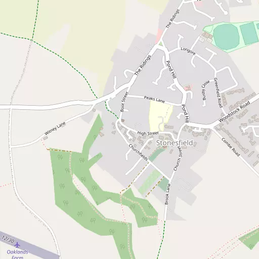
Stonesfield sits within Oxfordshire. Neighbouring places include Combe just 2.5 km East South East, East End only 2.6 km South South East, Finstock around 3.7 km West South West and Ramsden around 4.0 km West South West. Other countryside places nearby include Fawler, Wilcote, Woodleys, East End and Over Kiddington.
You may find out something new or interesting if you click a nearby place to see more local information.
Information is sourced from OS, ONS and OSM under open licence, using publicly available datasets.
⇅
Local Map
⇅
Location Summary
- Stonesfield is located in Oxfordshire
- Administrative Area: Oxfordshire
- Ceremonial County: Oxfordshire
- Historic County: Oxfordshire
- Region & Country: South East / England
⇅
Nearby Towns & Cities
- Charlbury 4.1 km NW
- Woodstock 5.4 km E
- Witney 8.1 km SSW
- Kidlington 10.4 km ESE
- Oxford 16.4 km SE


⇅
Nearby Localities
- CombeVillage 2.5 km ESE
- East EndVillage 2.6 km SSE
- FinstockVillage 3.7 km WSW
- RamsdenVillage 4.0 km WSW
- Long HanboroughVillage 4.2 km SE
- North LeighVillage 4.3 km S
- New YattVillage 4.5 km SSW
- FreelandVillage 4.6 km SSE
- Old WoodstockDistrict 5.0 km E
- Church HanboroughVillage 5.4 km SE


⇅
Smaller Settlements
- Fawler 2.0 km W
- Wilcote 2.6 km SW
- Woodleys 3.5 km NE
- East End 4.0 km ESE
- Over Kiddington 5.5 km NNE
- The Green 5.5 km SSE
- Glympton 5.7 km NE
- Whiteoak Green 5.8 km WSW
- Taston 5.9 km NNW
- Kiddington 6.1 km NNE


⇅
Beaches
- Cotswold Hills Beach42.0 km WSW
- Goatee Beach104.7 km S
- Sugar Loaf Beach101.9 km WSW
⇅
Parks
- Loop Meadow29.6 km SSE
- Merton Field16.8 km SE
- The Green26.3 km NE
- The Green29.2 km NNE
⇅
Woods
- Bridgefield Brake1.2 km SW
- Notoaks Wood1.4 km ESE
- Stockey Plantation435 m SSW
- Whitehill Wood1.6 km S
⇅
Hills
- Brook Hill2.7 km SE
- Dog Kennel Hill4.0 km ESE
- Grintley Hill2.6 km SE
- Jacob's Hill3.6 km ESE
⇅
Lakes
- Lake Superior4.4 km W
- Mapleton Pond2.6 km E
- North Leigh Reservoir4.4 km SSW
- Ridge Pool4.8 km WSW
⇅
Waterfalls
- Neptune Waterfall63.3 km ESE
- The Cascade34.6 km NE
- Tower Waterfall62.6 km ESE
⇅
Headlands
- Beachley Point88.2 km WSW
- Botany Bay Point75.7 km SE
⇅
Islands
- Fiddler's Island14.7 km SE
- Isle of Rhea15.5 km SE
⇅
Wetlands
- Ranger's Marsh6.0 km WNW
- Brassey25.7 km WNW
- Wanborough Marsh38.4 km SSW

⇅
Health Services
- Witney Community HospitalHospital 8.2 km SSW
- Chipping Norton War Memorial Community HospitalHospital 12.6 km NW
- Freeland HouseMedical 5.3 km SSE
- Middletown GrangeMedical 6.0 km SW
⇅
Education
- Stonesfield Primary SchoolSchool 158 m ENE
- Combe Church of England Primary SchoolSchool 2.5 km SE
- Common Leys Farm CampusUniversity 4.8 km SW

⇅
Railway Stations
- Finstock2.5 km W
- Combe3.4 km SE
⇅
Bus Stations
- Swindon Bus Station40.1 km SW
- Aylesbury Bus Station42.7 km E
⇅
Coach Stations
- Shakespeare's Birthplace Coach Terminal42.5 km NNW
- High Wycombe Coachway53.1 km ESE
⇅
Ferry Terminals
- Hampton Ferry Boathouse88.5 km ESE
- Hammerton's Pier89.3 km ESE
⇅
Airports
- London Oxford Airport7.9 km ESE
- Wellesbourne Mountford Airfield39.9 km NNW
⇅
Airfields
- Enstone Airfield8.6 km N
- Weston-on-the-Green Airfield15.0 km ENE

⇅
Heliports
- The London Heliport96.3 km ESE
- Magpas Air Ambulance99.7 km NE
⇅
Harbours
- Lydney Harbour75.7 km WSW
- Floating Harbour91.6 km WSW