
Tebworth
About Tebworth
Tebworth lies within Central Bedfordshire. Neighbouring places include Wingfield lying 871 m East South East, Hockliffe around 1.8 km West, Thorn lying 2.0 km South South East and Tilsworth just 2.5 km South South West. Other rural localities include Chalgrave, Bidwell, Chalk Hill, Fancott and Sewell.
You may find extra local information by clicking a nearby place.
Information is sourced from OS, ONS and OSM under open licence, using publicly available datasets.
⇅
Local Map
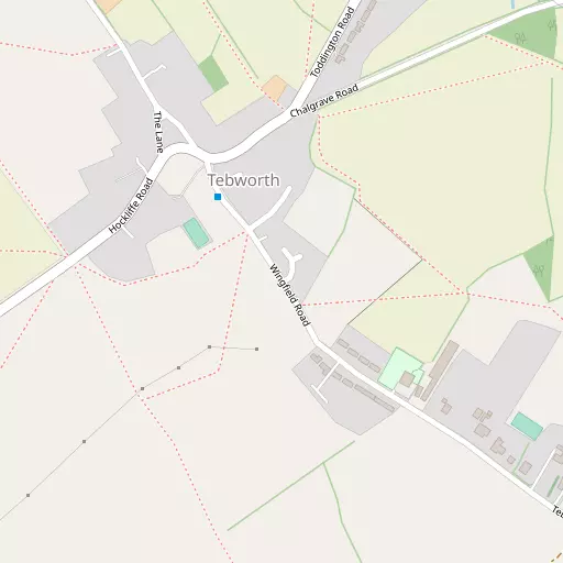
⇅
Location Summary
- Tebworth is located in Central Bedfordshire
- Administrative Area: Central Bedfordshire
- Ceremonial County: Bedfordshire
- Historic County: Central Bedfordshire
- Region & Country: Eastern / England
⇅
Nearby Towns & Cities
- Houghton Regis 3.7 km SE
- Dunstable 5.2 km SSE
- Leighton Buzzard 7.2 km W
- Woburn 7.9 km NNW
- Milton Keynes 18.5 km NW


⇅
Nearby Localities
- WingfieldVillage 871 m ESE
- HockliffeVillage 1.8 km W
- ThornVillage 2.0 km SSE
- TilsworthVillage 2.5 km SSW
- Church EndDistrict 2.6 km W
- ToddingtonVillage 2.9 km NE
- StanbridgeVillage 3.4 km SW
- Tithe FarmDistrict 3.7 km SE
- EggingtonVillage 3.7 km WSW
- ChaltonVillage 3.9 km E


⇅
Smaller Settlements
- Chalgrave 1.8 km ENE
- Bidwell 2.7 km SE
- Chalk Hill 3.1 km SSE
- Fancott 3.1 km ENE
- Sewell 3.6 km S
- Battlesden 3.8 km NW
- Linmere 4.0 km ESE
- Potsgrove 5.2 km NW
- Lower Sundon 5.6 km E
- Wood End 6.2 km NNE


⇅
Beaches
- Bell Wharf Beach94.0 km ESE
- Hadleigh Ray90.4 km ESE
- Mill Beach90.9 km ESE
⇅
Parks
- Balderson's Moor21.4 km SSE
- Chaulden Meadow20.7 km S
- Elfield Park17.0 km NW
- The Green20.5 km NW
⇅
Woods
- Dropshot Marsh1.8 km NE
- Great Wood1.7 km E
- Thorn Spring2.0 km SE
- Warrenmore Spinney2.2 km E
⇅
Hills
- Beech Hill5.9 km NNW
- Castle Hill4.6 km SSW
- Conger Hill3.0 km NE
- Purrets Hill6.6 km NNW
⇅
Lakes
- Bright's Pond5.5 km ENE
- Linden Lake6.0 km N
- Tebworth Pond256 m N
- Upper Hopgarden Pond6.1 km NNW

⇅
Waterfalls
- Neptune Waterfall27.9 km S
- The Cascade33.1 km WNW
- Tower Waterfall27.6 km S

⇅
Headlands
- Botany Bay Point57.6 km S
- Tripcock Ness64.7 km SE
⇅
Islands
- Bird Island14.9 km N
- Rink Islands23.8 km NNE
⇅
Wetlands
- Waterford Marsh34.3 km ESE
- Summer Leys38.6 km NNW
- Cock Marsh41.1 km SSW
⇅
Health Services
- St Mary's WingHospital 6.9 km ESE
- Steppingley HospitalHospital 9.8 km NNE
- Orchard Lodge Nursing HomeMedical 2.8 km SW
- Leighton Rose Care HomeMedical 5.3 km W
⇅
Education
- Hockliffe Lower SchoolSchool 2.0 km WNW
- St George Lower School ToddingtonSchool 2.8 km NNE
- University of BedfordshireUniversity 11.6 km ESE
⇅
Railway Stations
- Stonehenge Works5.2 km WNW
- Harlington5.6 km NE
⇅
Bus Stations
- Bletchley Bus Station14.1 km WNW
- Aylesbury Bus Station21.6 km SW
⇅
Coach Stations
- Luton Airport Bus and Coach Station13.7 km ESE
- Milton Keynes Coachway17.1 km NW
⇅
Ferry Terminals
- Embankment Pier55.7 km SSE
- Festival Pier55.9 km SSE
⇅
Airports
- London Luton Airport14.4 km ESE
- London Elstree Aerodrome34.2 km SSE
⇅
Airfields
- Holmbeck Farm Airfield11.9 km W
- Cranfield Airport16.2 km NNW
⇅
Heliports
- Magpas Air Ambulance54.2 km NNE
- The London Heliport57.3 km SSE
⇅
Harbours
- Chelsea Harbour56.7 km SSE
- Cutter's Dock106.3 km ESE