
Weedon
About Weedon
Weedon, in Buckinghamshire, has Hardwick around 1.4 km North West, Watermead just 2.8 km South South East, Berryfields lying 2.8 km South West, Quarrendon around 3.1 km South South West and Whitchurch lying 3.1 km North North West. Other rural communities nearby include Hunters Yard, Creslow, Hulcott and Fleet Marston.
You may notice something interesting if you explore one of the nearby places.
The information presented here is derived from OS, ONS and OSM under open licence.
⇅
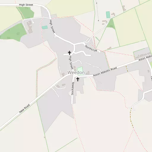
Local Map
⇅
Location Summary
- Weedon is located in Buckinghamshire
- Administrative Area: Buckinghamshire
- Ceremonial County: Buckinghamshire
- Historic County: Buckinghamshire
- Region & Country: South East / England
⇅
Nearby Towns & Cities
- Aylesbury 4.3 km S
- Winslow 10.4 km NNW
- Wendover 11.6 km SSE
- Leighton Buzzard 12.8 km ENE
- Milton Keynes 21.3 km NNE


⇅
Nearby Localities
- HardwickVillage 1.4 km NW
- WatermeadDistrict 2.8 km SSE
- BerryfieldsDistrict 2.8 km SW
- QuarrendonDistrict 3.1 km SSW
- WhitchurchVillage 3.1 km NNW
- ElmhurstDistrict 3.4 km SSE
- BiertonVillage 3.5 km SE
- RowshamVillage 3.6 km E
- Haydon HillDistrict 3.8 km SSW
- Manor ParkDistrict 3.8 km SSE


⇅
Smaller Settlements
- Hunters Yard 3.4 km NNW
- Creslow 3.7 km N
- Hulcott 4.1 km ESE
- Fleet Marston 4.3 km WSW
- Broughton Crossing 4.3 km SE
- Pitchcott 4.4 km WNW
- Dunton 6.1 km N
- Littlecote 6.6 km NNE
- Sedrup 6.7 km SSW
- Crafton 7.9 km E


⇅
Beaches
- Cotswold Hills Beach81.5 km WSW
- Hadleigh Ray103.5 km ESE
- Mill Beach107.1 km E
⇅
Parks
- Balderson's Moor26.8 km ESE
- Chaulden Meadow25.1 km ESE
- Elfield Park18.5 km NNE
- The Green24.0 km N
⇅
Woods
- Evelyn's Patch1.1 km SSE
- Fox Covert3.5 km ENE
- Freemasons Wood3.1 km NE
- The Green4.1 km ESE

⇅
Hills
- Burston Hill2.1 km ENE
- Park Hill5.9 km SSW
- Pitchcott Hill4.8 km WNW
- Windmill Hill2.9 km ENE
⇅
Lakes
- Biggin Pond8.9 km SSW
- Garden Pond8.4 km ENE
- Oakfield Lake4.9 km SE
- Washbrook5.1 km NW
⇅
Waterfalls
- Neptune Waterfall26.8 km SE
- The Cascade23.3 km NW
- Tower Waterfall26.1 km SE
⇅
Headlands
- Botany Bay Point51.7 km SSE
- Tripcock Ness73.7 km ESE
⇅
Islands
- China Island13.9 km W
- Grotto Island13.6 km W

⇅
Wetlands
- Cock Marsh32.0 km SSE
- Wargrave Marsh38.2 km S
- Ickenham Marsh42.7 km SE
⇅
Health Services
- The International Spinal Injuries and Rehabilitation CentreHospital 3.9 km S
- The Whiteleaf CentreHospital 4.1 km SSE
- Buckingham LodgeMedical 2.4 km S
- Lakeside Care CentreMedical 2.9 km SSE
⇅
Education
- Buckingham Park Church of England Primary SchoolSchool 2.4 km S
- Green Ridge Primary AcademySchool 3.1 km WSW
- Buckinghamshire New UniversityUniversity 4.7 km S
⇅
Railway Stations
- Aylesbury Vale Parkway3.9 km SW
- Aylesbury4.7 km S
⇅
Bus Stations
- Aylesbury Bus Station4.5 km S
- Bletchley Bus Station16.6 km NNE
⇅
Coach Stations
- Milton Keynes Coachway23.7 km NNE
- High Wycombe Coachway27.1 km S
⇅
Ferry Terminals
- Hammerton's Pier57.3 km SE
- Hampton Ferry Boathouse58.5 km SSE
⇅
Airports
- Wycombe Air Park27.4 km S
- London Luton Airport31.2 km E
⇅
Airfields
- Holmbeck Farm Airfield8.6 km NE
- Halton Airfield9.1 km SE
⇅
Heliports
- The London Heliport61.6 km SE
- Magpas Air Ambulance69.9 km NNE
⇅
Harbours
- Chelsea Harbour61.0 km SE
- Hendy's Quay112.8 km S