
Amersham
About Amersham
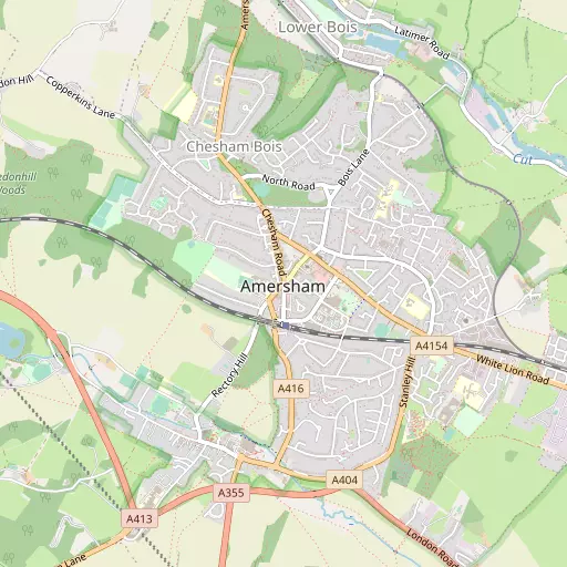
Amersham, in Buckinghamshire, has Amersham on the Hill situated 309 m East South East, Chesham Bois lying 752 m North, Amersham Common situated 1.0 km South East, Bury End situated 1.2 km South and Amersham Old Town situated 1.3 km South West. Other places in the surrounding countryside include The Broadway, Little Chalfont, Woodrow and Griffitts Yard.
You might discover something new by clicking a nearby place for more local details.
These details are compiled from OS, ONS and OSM data released under open licence.
⇅
Local Map
⇅
Location Summary
- Amersham is located in Buckinghamshire
- Administrative Area: Buckinghamshire
- Ceremonial County: Buckinghamshire
- Historic County: Buckinghamshire
- Region & Country: South East / England
⇅
Nearby Towns & Cities
- Chesham 3.1 km N
- Chorleywood 6.4 km ESE
- Beaconsfield 7.8 km SSW
- Berkhamsted 9.9 km NNE
- St Albans 20.3 km ENE


⇅
Nearby Localities
- Amersham on the HillDistrict 309 m ESE
- Chesham BoisDistrict 752 m N
- Amersham CommonDistrict 1.0 km SE
- Bury EndDistrict 1.2 km S
- Amersham Old TownDistrict 1.3 km SW
- Lower BoisDistrict 1.8 km NNE
- WatersideDistrict 2.5 km N
- ChessmountDistrict 2.5 km N
- Pednormead EndDistrict 2.9 km NNW
- ColeshillVillage 3.6 km SSW


⇅
Smaller Settlements
- The Broadway 3.3 km N
- Little Chalfont 3.3 km ESE
- Woodrow 3.6 km SW
- Griffitts Yard 3.9 km N
- Mop End 4.2 km WSW
- Beamond End 5.1 km WSW
- Hyde End 5.2 km WNW
- Heath End 8.3 km N
- Micklefield Green 8.4 km E
- Hunt's Green 8.5 km NW


⇅
Beaches
- Bell Wharf Beach88.4 km E
- Chapman Sands88.2 km E
- Hadleigh Ray84.3 km E
⇅
Parks
- Balderson's Moor11.8 km NE
- Bell Meadow19.6 km ENE
- Chaulden Meadow10.7 km NE
- Seabrook Meadow18.9 km ENE

⇅
Woods
- Chesham Bois Common666 m N
- Copperkins Dell740 m WSW
- First Charsleys Wood1.0 km W
- Parsonage Wood528 m SSW

⇅
Hills
- Bishop's Hill3.7 km NW
- Gore Hill2.4 km SSW
- King's Hill4.4 km E
- Ley Hill3.9 km NE
⇅
Lakes
- Bricky Pond718 m N
- Great Water River Chess3.2 km E
- Kingfisher Lake1.9 km NNE
- Skottowe's Pond3.2 km N
⇅
Waterfalls
- Neptune Waterfall3.6 km E
- The Cascade47.9 km NW
- Tower Waterfall2.9 km E
⇅
Headlands
- Botany Bay Point29.5 km S
- Tripcock Ness51.8 km ESE
⇅
Islands
- Bradbury's Island12.7 km SSE
- Slow Grove15.5 km SSW

⇅
Wetlands
- Cock Marsh14.0 km SW
- Ickenham Marsh18.1 km SE
- Wargrave Marsh25.8 km SW
⇅
Health Services
- Amersham HospitalHospital 1.9 km SSW
- The Chiltern HospitalHospital 6.2 km WNW
- Rayners Nursing HomeMedical 3.6 km WNW
- DapplemereMedical 7.2 km ESE
⇅
Education
- Dr Challoner's Grammar SchoolSchool 285 m W
- Heatherton House SchoolSchool 732 m NNW
- National Film and Television SchoolUniversity 8.2 km SSW
⇅
Railway Stations
- Chesham3.3 km N
- Chalfont and Latimer3.3 km ESE
⇅
Bus Stations
- High Wycombe Bus Station11.4 km WSW
- Slough Bus Station18.4 km S
⇅
Coach Stations
- High Wycombe Coachway12.8 km WSW
- Luton Airport Bus and Coach Station27.6 km NE
⇅
Ferry Terminals
- Hammerton's Pier32.6 km SE
- Hampton Ferry Boathouse33.9 km SSE
⇅
Airports
- Wycombe Air Park15.6 km WSW
- London Elstree Aerodrome19.6 km E
⇅
Airfields
- Bovingdon Airfield7.0 km NE
- Denham Aerodrome11.7 km SSE
⇅
Heliports
- The London Heliport37.5 km SE
- The Egerton-Smith Centre79.5 km NE
⇅
Harbours
- Chelsea Harbour37.0 km SE
- Hendy's Quay95.4 km SSW