
Chyandour, Trevarrack
About Chyandour
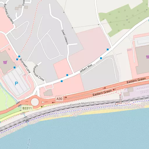
Chyandour sits 575 m N of Trevarrack in Cornwall. Neighbouring places include Gulval only 575 m North, Trythogga situated 596 m West North West, Trevarrack situated 675 m North West and Treneere just 1.4 km West. Other nearby settlements include Newtown, Vellanoweth, Trereife, Tregavarah and Tremethick Cross.
You might discover something new by clicking a nearby place for more local details.
All information is drawn from OS, ONS and OSM under open licence, reflecting the best available public data.
⇅
Local Map
⇅
Location Summary
- Chyandour is a neighbourhood in Trevarrack
- Administrative Area: Cornwall
- Ceremonial County: Cornwall
- Historic County: Cornwall
- Region & Country: South West / England
⇅
Nearby Towns & Cities


⇅
Nearby Localities


⇅
Smaller Settlements
- Newtown 2.4 km ENE
- Vellanoweth 3.3 km NE
- Trereife 3.5 km WSW
- Tregavarah 4.0 km WSW
- Tremethick Cross 4.1 km WSW
- Gwallon 4.3 km ENE
- Lower Ninnes 4.3 km NW
- Mulfra 4.5 km NW
- Boswarthen 4.6 km WNW
- Carfury 4.8 km NW
⇅
Beaches
- Kenneggy Sand8.4 km ESE
- Long Rock746 m E
- Perran Sands6.0 km ESE

⇅
Parks
- Lanner Moor25.3 km ENE
- Palm Cross Green118.7 km ENE
- Summerleaze Down104.5 km NE
- Trungle Moor4.7 km SSW

⇅
Woods
- Bog Plantation2.6 km ENE
- Hellangove Plantation2.7 km N
- Price's Folly4.2 km SW
- Stennacks Plantation3.0 km ENE
⇅
Hills
- Castle-an-Dinas3.8 km N
- Lescudjack Hill857 m WSW
- Mulfra Hill5.3 km NW
- Rose Hill3.6 km E
⇅
Lakes
- Boscathnoe Reservoir3.0 km W
- Drift Reservoir5.3 km WSW
- Nance Fishing Lakes7.0 km NNE
- Sheffield Quarry5.3 km SSW

⇅
Waterfalls
- Golitha Falls82.7 km ENE
- White Lady Waterfall114.1 km ENE
- Yealm Steps117.6 km ENE
⇅
Headlands
- Cudden Point7.5 km ESE
- Gurnard's Head9.0 km NW
⇅
Islands
- St Michael's Mount3.4 km ESE
- The Enys11.5 km WNW
⇅
Wetlands
- Marazion Marsh3.0 km ENE
- Basore Point5.2 km ESE
- Arch Zawn7.4 km ESE
⇅
Health Services
- West Cornwall HospitalHospital 1.6 km WSW
- PengarthHospital 1.6 km SW
- Ponsandane Nursing and Residential HomeMedical 379 m W
- Trevaylor Manor Nursing HomeMedical 1.9 km NW
⇅
Education
- Gulval SchoolSchool 569 m NNW
- St Mary's Roman Catholic SchoolSchool 975 m W
- Cornwall College of Further and Higher EducationUniversity 20.8 km ENE

⇅
Railway Stations
- Penzance913 m SW
- St Erth7.4 km NE
⇅
Bus Stations
- Penzance Bus Station956 m SW
- St Ives9.8 km NNE
⇅
Coach Stations
- Plymouth Coach Station101.8 km ENE
- Torquay Coach Station146.2 km ENE
⇅
Ferry Terminals
- Penzance Ferry Terminal1.3 km SSW
- Trelissick36.6 km ENE
⇅
Airports
- Land's End Airport11.0 km WSW
- Newquay Cornwall Airport50.1 km NE
⇅
Airfields
- Royal Navy Air Station Culdrose20.1 km ESE
- Predannack Airfield25.1 km SE

⇅
Heliports
- Penzance Heliport755 m ENE
- Cornwall Air Ambulance Station51.2 km NE
⇅
Harbours
- Newlyn Harbour3.2 km SSW
- Mousehole Harbour5.1 km SSW