
Coffinswell
About Coffinswell
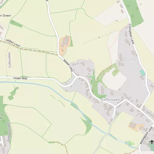
Coffinswell, in Devon, has Kingskerswell around 1.3 km South West, Aller Park only 1.5 km North North West, Newtake situated 1.5 km North North West, Milber only 2.0 km North West and Buckland lying 2.6 km North North West. Other rural areas close to here include Daccombe, Middle Rocombe, Netherton and Higher Rocombe.
You may find out something new or interesting if you click a nearby place to see more local information.
Information is sourced from OS, ONS and OSM under open licence, using publicly available datasets.
⇅
Local Map
⇅
Location Summary
- Coffinswell is located in Devon
- Administrative Area: Devon
- Ceremonial County: Devon
- Historic County: Devon
- Region & Country: South West / England
⇅
Nearby Towns & Cities
- Newton Abbot 3.7 km NW
- Kingsteignton 4.6 km NNW
- Torquay 5.2 km SSE
- Teignmouth 6.8 km NE
- Exeter 24.0 km N


⇅
Nearby Localities
- KingskerswellVillage 1.3 km SW
- Aller ParkDistrict 1.5 km NNW
- NewtakeDistrict 1.5 km NNW
- MilberDistrict 2.0 km NW
- BucklandDistrict 2.6 km NNW
- BartonDistrict 2.7 km SE
- EdginswellDistrict 2.7 km S
- AbbotskerswellVillage 3.0 km W
- WolboroughDistrict 3.1 km WNW
- CombeinteignheadVillage 3.1 km NNE


⇅
Smaller Settlements
- Daccombe 1.7 km ESE
- Middle Rocombe 2.3 km ENE
- Netherton 2.5 km N
- Higher Rocombe 2.6 km E
- Lower Rocombe 2.6 km ENE
- North Whilborough 2.9 km SSW
- Dainton 4.0 km WSW
- Two Mile Oak Cross 4.1 km WSW
- Teigngrace 6.3 km NW
- West Ogwell 6.6 km W


⇅
Beaches
- Maidencombe Beach4.1 km E
- Watcombe Beach4.2 km ESE
- Whitsand Beach4.3 km ESE
⇅
Parks
- Palm Cross Green28.7 km SW
- Pennsylvania Park25.7 km N
- Pleasure Grounds39.2 km NW
- The Lawn10.8 km NE
⇅
Woods
- Aller Orchard Wood899 m WNW
- Aller Park Brake1.2 km NW
- Connybear Brake689 m NE
- Harpins Brake541 m WSW
⇅
Hills
- Farradon Hill3.1 km SW
- Great Hill2.7 km ESE
- Kerswell Down Hill2.3 km SW
- Kerswell Hill583 m S
⇅
Lakes
- Abbrook Pond6.1 km NNW
- Bickley Pond3.4 km SW
- Well Head5.1 km NNW
- Zitherixon Clay Works4.4 km NNW
⇅
Waterfalls
- Becka Falls16.9 km NW
- Broad Falls23.4 km W
- Horseshoe Falls17.6 km W
⇅
Headlands
- Bundle Head5.5 km ENE
- Watcombe Head4.2 km ESE
⇅
Islands
- Ore Stone9.1 km SE
- Thatcher Rock8.3 km SE
⇅
Wetlands
- Buckland Point3.3 km N
- Netherton Point3.3 km N
- Hackney Marshes3.4 km NNW
⇅
Health Services
- Torbay Hospital AnnexeHospital 2.8 km SSE
- Torbay HospitalHospital 3.2 km SSE
- Lynwood LodgeMedical 2.8 km ESE
- Mount TryonMedical 6.0 km SE
⇅
Education
- Kingskerswell Church of England Primary SchoolSchool 848 m SSW
- Decoy Community Primary SchoolSchool 2.1 km WNW
- South Devon College Brunel CentreUniversity 2.9 km NNW
⇅
Railway Stations
- Newton Abbot3.0 km NW
- Torre4.3 km SSE
⇅
Bus Stations
- Exeter Bus Station24.4 km N
- Kingsbridge Bus Station29.0 km SSW
⇅
Coach Stations
- Torquay Coach Station4.6 km SSE
- Plymouth Coach Station43.3 km WSW
⇅
Ferry Terminals
- Greenway Quay14.1 km S
- Starcross Pier15.9 km NE
⇅
Airports
- Exeter Airport27.5 km NNE
- Plymouth City Airport39.2 km WSW
⇅
Airfields
- Bolt Head Airfield35.4 km SSW
- Farway Common Airfield37.5 km NE
⇅
Heliports
- Lake Heliport75.4 km NW
- Hartland Heliport87.5 km NW
⇅
Harbours
- Old Harbour6.3 km SSE
- New Harbour6.3 km SSE