
Heddle
About Heddle
Heddle is on the island of Mainland in Orkney Islands. Places nearby include Finstown only 1.2 km North North East, Bimbister lying 4.4 km North West, Stenness only 5.0 km West and Clouston situated 6.0 km West South West. Other countryside places nearby include Grimbister, Germiston, Tuskerbister, Cursiter and Horraldshay.
You might discover something new by clicking a nearby place for more local details.
All place information is taken from OS, ONS and OSM under open licence.
⇅
Local Map
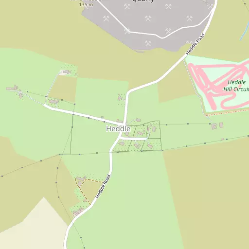
⇅
Location Summary
- Heddle is located in Orkney Islands
- Administrative Area: Orkney Islands
- Ceremonial County: Orkney Islands
- Historic County: Orkney Islands
- Region & Country: Scotland / Scotland
- Island: Mainland
⇅
Nearby Towns & Cities


⇅
Nearby Localities


⇅
Smaller Settlements
- Grimbister 1.5 km E
- Germiston 1.6 km SW
- Tuskerbister 2.2 km S
- Cursiter 2.4 km E
- Horraldshay 2.6 km NNE
- Coubister 3.5 km NNE
- Quatquoy 3.8 km NNE
- Grimeston 4.8 km WNW
- Kirbister 5.1 km S
- Smerquoy 5.3 km ESE


⇅
Beaches
- Sands of Congesquoy8.1 km WSW
- Sands of Fidgeon2.2 km E
- Sands of Piggar7.8 km S
⇅
Parks
- Ferry Muir335.5 km S
- Fountain Green346.7 km S
- Kinnoull Hill Woodland Park290.0 km S
- West Green328.4 km S
⇅
Woods
- Heathshield Wood40.9 km SSW
- Hoy Forest14.9 km WSW
- Stroupster Forest46.8 km S
- Tothel Gill Forest45.4 km S
⇅
Hills
- Cuffie Hill2.6 km N
- Hill of Heddle509 m NNW
- Hill of Lyradale1.7 km SSE
- Nearhouse Hill2.6 km S


⇅
Lakes
- Leisburn5.0 km NE
- Loch of Kirbister4.8 km SSE
- Loch of Wasdale2.6 km NNW
- Mill Pond6.3 km SE

⇅
Waterfalls
- An t-Eas63.9 km SSW
- Eas Gluta86.5 km SSW
- Easan na Buaile87.8 km SSW
⇅
Headlands
- Chapel Point4.5 km NE
- Point of Backaquoy4.7 km NE
⇅
Islands
- Damsay3.8 km ENE
- Holm of Grimbister2.6 km ENE

⇅
Wetlands
- Thickbigging1.3 km NNE
- Holm Point2.2 km ENE
- Skerries of Coubister3.2 km NE
⇅
Health Services
- The BalfourHospital 9.4 km ESE
- Dunbar HospitalHospital 51.7 km SSW
- Pentland View Nursing HomeMedical 50.1 km SSW
- Seaview HouseMedical 61.3 km S
⇅
Education
- Firth Primary SchoolSchool 1.8 km NNE
- Stenness Community SchoolSchool 4.9 km WSW
- University of the Highlands and IslandsUniversity 9.5 km E
⇅
Railway Stations
- Thurso50.8 km SSW
- Georgemas Junction56.8 km SSW
⇅
Bus Stations
- Kirkwall Bus Station9.4 km E
- Elgin Bus Station150.1 km S
⇅
Coach Stations
- Newcastle Coach Station457.0 km SSE
- Gateshead Interchange457.9 km SSE
⇅
Ferry Terminals
- Kirkwall Hatston Ferry Terminal8.5 km E
- Houton Ferry Terminal9.4 km SSW
⇅
Airports
- Kirkwall Airport13.6 km ESE
- London Airport29.8 km NE
⇅
Airfields
- Lamb Holm International18.0 km SE
- Aiker Ness Airfield40.7 km NNE
⇅
Heliports
- Glasgow City Heliport355.2 km SSW
- Newcastle City Heliport457.6 km SSE
⇅
Harbours
- Kirkwall Harbour9.6 km E
- Stromness Harbour10.6 km WSW