
Knowles Hill, Newton Abbot
About Knowles Hill
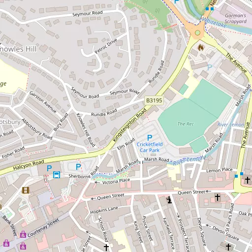
Knowles Hill lies 327 m W from Newton Abbot in Devon. Local places nearby include Abbotsbury only 327 m West, Broadlands only 944 m West, Wolborough only 1.2 km South and Milber lying 1.7 km South East. Other local places include Teigngrace, Netherton, Preston, Two Mile Oak Cross and West Ogwell.
You might discover something new by clicking a nearby place for more local details.
The details shown here use OS, ONS and OSM data provided under open licence.
⇅
Local Map
⇅
Location Summary
- Knowles Hill is a neighbourhood in Newton Abbot
- Administrative Area: Devon
- Ceremonial County: Devon
- Historic County: Devon
- Region & Country: South West / England
⇅
Nearby Towns & Cities
- Parent town: Newton Abbot
- Newton Abbot 234 m SSW
- Kingsteignton 1.8 km NNE
- Teignmouth 8.1 km E
- Chudleigh 8.1 km N
- Exeter 21.8 km NNE


⇅
Nearby Localities
- AbbotsburyDistrict 327 m W
- BroadlandsDistrict 944 m W
- WolboroughDistrict 1.2 km S
- MilberDistrict 1.7 km SE
- BucklandDistrict 1.8 km E
- Mile EndDistrict 2.1 km WNW
- Aller ParkDistrict 2.3 km SE
- NewtakeDistrict 2.4 km ESE
- East OgwellVillage 2.6 km SW
- AbbotskerswellVillage 2.8 km S


⇅
Smaller Settlements
- Teigngrace 2.6 km NNW
- Netherton 3.0 km E
- Preston 3.2 km N
- Two Mile Oak Cross 3.8 km SSW
- West Ogwell 4.2 km WSW
- Combe 4.5 km NNE
- Dainton 4.9 km S
- Lower Rocombe 5.0 km ESE
- North Whilborough 5.2 km S
- South Knighton 5.2 km W


⇅
Other places with this name
- Knowles Hill, Kent 300.7 km ENE

⇅
Beaches
- Cherryred Beach7.5 km E
- Maidencombe Beach7.3 km ESE
- Shaldon Beach7.5 km E
⇅
Parks
- Palm Cross Green28.5 km SW
- Pennsylvania Park23.6 km NNE
- Pleasure Grounds35.5 km NW
- The Lawn11.2 km ENE

⇅
Woods
- Berry's Wood1.4 km WSW
- Blackball Plantation1.6 km S
- Lang's Copse1.5 km SW
- Wildwoods Copse1.5 km E
⇅
Hills
- Canada Hill2.4 km SW
- East Hill2.2 km SW
- Emblett Hill2.1 km WSW
- Gaze Hill1.6 km WNW
⇅
Lakes
- Abbrook Pond3.0 km N
- Upper Lake2.6 km NW
- Well Head2.5 km NNE
- Zitherixon Clay Works1.1 km NNE
⇅
Waterfalls
- Becka Falls13.2 km NW
- Broad Falls21.3 km WSW
- Horseshoe Falls15.1 km W
⇅
Headlands
- Bundle Head7.4 km E
- Watcombe Head7.7 km ESE
⇅
Islands
- Dartington Island10.6 km SW
- Hood Island11.7 km SW
⇅
Wetlands
- Hackney Marshes1.6 km ENE
- Buckland Point2.3 km ENE
- Netherton Point3.0 km ENE
⇅
Health Services
- Newton Abbot Community HospitalHospital 847 m NNW
- Torbay Hospital AnnexeHospital 6.4 km SE
- Bramble DownMedical 4.9 km SW
- Lynwood LodgeMedical 6.4 km SE
⇅
Education
- Bearnes (Voluntary) Primary SchoolSchool 199 m SE
- Technical CollegeSchool 207 m NE
- South Devon College Brunel CentreUniversity 1.1 km E

⇅
Railway Stations
- Newton Abbot721 m ESE
- Teigngrace2.9 km NNW
⇅
Bus Stations
- Exeter Bus Station22.3 km NNE
- Kingsbridge Bus Station30.2 km SSW
⇅
Coach Stations
- Torquay Coach Station8.2 km SE
- Plymouth Coach Station41.9 km WSW
⇅
Ferry Terminals
- Starcross Pier15.5 km NE
- Greenway Quay16.7 km S
⇅
Airports
- Exeter Airport26.4 km NNE
- Plymouth City Airport37.5 km WSW
⇅
Airfields
- Bolt Head Airfield36.8 km SSW
- Farway Common Airfield37.8 km NE
⇅
Heliports
- Lake Heliport71.7 km NW
- Hartland Heliport83.8 km NW
⇅
Harbours
- Old Harbour9.9 km SE
- New Harbour9.9 km SE