
Lacey Green, Lacey Green and Loosley Row
About Lacey Green
Lacey Green is positioned 858 m WNW from Lacey Green and Loosley Row in Buckinghamshire. Local places nearby include Loosley Row lying 858 m West North West, Speen situated 1.4 km East South East, Saunderton Lee only 1.7 km West South West, Walter's Ash lying 2.2 km South South East and Saunderton situated 2.3 km South South West. Other places in the wider area include Parslow's Hillock, Green Hailey, Lower North Dean and Rout's Green.
You may find extra local information by clicking a nearby place.
Information is sourced from OS, ONS and OSM under open licence, using publicly available datasets.
⇅
Local Map
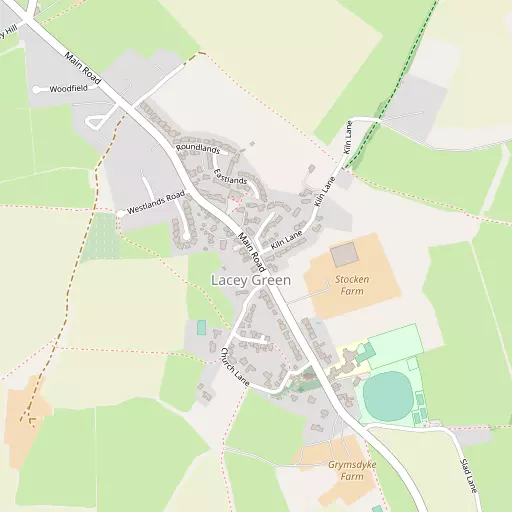
⇅
Location Summary
- Lacey Green is a neighbourhood in Lacey Green and Loosley Row
- Administrative Area: Buckinghamshire
- Ceremonial County: Buckinghamshire
- Historic County: Buckinghamshire
- Region & Country: South East / England
⇅
Nearby Towns & Cities
- Parent town: Lacey Green and Loosley Row
- Princes Risborough 3.7 km NNW
- High Wycombe 8.4 km SSE
- Wendover 8.9 km NNE
- Thame 13.2 km WNW
- Oxford 31.5 km WNW


⇅
Nearby Localities
- Loosley RowVillage 858 m WNW
- SpeenVillage 1.4 km ESE
- Saunderton LeeVillage 1.7 km WSW
- Walter's AshVillage 2.2 km SSE
- SaundertonVillage 2.3 km SSW
- Great HampdenVillage 2.8 km ENE
- Bryant's BottomVillage 3.0 km E
- Upper North DeanVillage 3.1 km ESE
- BradenhamVillage 3.1 km S
- SaundertonVillage 3.4 km WNW


⇅
Smaller Settlements
- Parslow's Hillock 1.8 km NNE
- Green Hailey 3.0 km N
- Lower North Dean 3.5 km ESE
- Rout's Green 3.9 km WSW
- Stony Green 3.9 km E
- Horsenden 4.0 km NW
- Alscot 4.8 km NNW
- Lower Cadsden 4.9 km N
- Green End 5.0 km SSW
- Prestwood 5.1 km E


⇅
Other places with this name
- Lacey Green, Cheshire East 206.5 km NNW
⇅
Beaches
- Cotswold Hills Beach79.4 km W
- Weston Hard98.3 km SSW
- Weston Point98.0 km SSW

⇅
Parks
- Balderson's Moor23.7 km ENE
- Chaulden Meadow22.1 km ENE
- Hog Common28.8 km SSE
- The Common25.7 km SSW
⇅
Woods
- Beamangreen Wood1.2 km SSE
- Bradenham Wood1.4 km S
- Hillocks Field Plantation1.7 km NNE
- Munt's Wood1.4 km SW

⇅
Hills
- Callows Hill897 m WSW
- Hemley Hill2.7 km NW
- Pink Hill1.3 km N
- Slough Hill2.6 km SW
⇅
Lakes
- Cockpit Hole6.1 km ESE
- Cross Lane Pond4.5 km SW
- Deep Pit Pond166 m NE
- Wibner Pond5.0 km ENE

⇅
Waterfalls
- Neptune Waterfall17.6 km E
- The Cascade39.6 km NNW
- Tower Waterfall16.9 km E
⇅
Headlands
- Botany Bay Point34.7 km SSE
- Tripcock Ness65.6 km ESE
⇅
Islands
- Lock Island14.4 km SSE
- Taylor Island14.6 km SSE
⇅
Wetlands
- Cock Marsh14.6 km SSE
- Wargrave Marsh20.5 km SSW
- Ickenham Marsh30.3 km ESE
⇅
Health Services
- The Chiltern HospitalHospital 8.0 km E
- The Shelburne HospitalHospital 8.5 km SSE
- Cherry Tree Nursing HomeMedical 3.3 km WNW
- The HeightsMedical 5.7 km SSE
⇅
Education
- St John's Church of England (Voluntary Aided) Combined SchoolSchool 365 m SE
- Speen Church of England (Voluntary Aided) SchoolSchool 1.7 km ESE
- GatewayUniversity 8.3 km SSE

⇅
Railway Stations
- Saunderton2.3 km SSW
- Princes Risborough3.5 km NW
⇅
Bus Stations
- High Wycombe Bus Station7.9 km SSE
- Aylesbury Bus Station13.5 km N
⇅
Coach Stations
- High Wycombe Coachway9.4 km SSE
- Luton Airport Bus and Coach Station36.3 km NE
⇅
Ferry Terminals
- Hammerton's Pier43.9 km SE
- Hampton Ferry Boathouse44.0 km SE
⇅
Airports
- Wycombe Air Park9.4 km S
- London Elstree Aerodrome33.6 km E
⇅
Airfields
- Halton Airfield11.9 km NNE
- Bovingdon Airfield18.7 km E
⇅
Heliports
- The London Heliport50.2 km ESE
- Magpas Air Ambulance85.1 km NNE
⇅
Harbours
- Chelsea Harbour49.8 km ESE
- Hendy's Quay95.0 km S