
Portscatho
About Portscatho
Portscatho lies within Cornwall. Among the nearby places are Gerrans around 402 m West South West, St Just in Roseland lying 2.4 km West, St Mawes around 3.6 km South West and Veryan only 5.7 km North East. Other countryside settlements include Trewithian, Bohortha, Treworlas, Philleigh and Carne.
You may find out something new or interesting if you click a nearby place to see more local information.
The information presented here is derived from OS, ONS and OSM under open licence.
⇅
Local Map
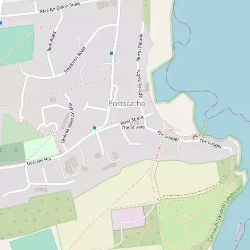
⇅
Location Summary
- Portscatho is located in Cornwall
- Administrative Area: Cornwall
- Ceremonial County: Cornwall
- Historic County: Cornwall
- Region & Country: South West / England
⇅
Nearby Towns & Cities
- Falmouth 7.6 km WSW
- Penryn 9.2 km W
- Redruth 18.8 km WNW
- St Austell 22.0 km NE
- Truro 10.8 km NNW


⇅
Nearby Localities
- GerransVillage 402 m WSW
- St Just in RoselandVillage 2.4 km W
- St MawesVillage 3.6 km SW
- VeryanVillage 5.7 km NE
- HarcourtVillage 6.1 km WNW
- FeockVillage 6.2 km WNW
- Veryan GreenVillage 6.3 km NE
- TrelewVillage 6.4 km W
- FlushingVillage 6.9 km WSW
- Ruan LanihorneVillage 7.0 km NNE


⇅
Smaller Settlements
- Trewithian 1.9 km NNE
- Bohortha 3.4 km SSW
- Treworlas 3.8 km NNE
- Philleigh 4.1 km N
- Carne 4.8 km NE
- Ruan High Lanes 5.4 km NNE
- Treworga 5.4 km NNE
- Mylor Churchtown 5.7 km W
- Trelissick 5.9 km NW
- Restronguet Weir 6.0 km WNW


⇅
Beaches
- Porthbean Beach1.6 km NNE
- Porthcurnick Beach755 m NNE
- Towan Beach2.3 km S

⇅
Parks
- Lanner Moor16.1 km WNW
- Palm Cross Green79.5 km ENE
- Summerleaze Down78.8 km NNE
- Trungle Moor42.3 km WSW

⇅
Woods
- Camerance Wood4.3 km NW
- Cellars Plantation3.8 km SW
- Drawler Plantation3.4 km SSW
- Tolcarne Wood4.8 km NW
⇅
Hills
- Castle Hill14.9 km NE
- Puckey's Hill7.8 km NE
- Trenoweth Hill15.3 km SSW
- Tubbon Hill13.7 km W
⇅
Lakes
- College Reservoir10.9 km WSW
- Merther Pond8.6 km NNW
- Swan Pool8.3 km WSW
- Tresemple Pond9.6 km NNW
⇅
Waterfalls
- Golitha Falls48.0 km NE
- White Lady Waterfall78.7 km NE
- Yealm Steps79.2 km ENE
⇅
Headlands
- Messack Point3.5 km W
- Roseland Peninsula2.9 km NNW
⇅
Islands
- Gull Island23.9 km NE
- The Island25.9 km SW
⇅
Wetlands
- Priory Point2.3 km SW
- North-hill Point2.5 km SW
- Black Rock3.1 km SW
⇅
Health Services
- Falmouth HospitalHospital 8.3 km WSW
- Treliske HospitalHospital 12.7 km NW
- Eshcol HouseMedical 115 m NNW
- LangholmeMedical 7.1 km WSW
⇅
Education
- Gerrans SchoolSchool 506 m SW
- St Mawes Community Primary SchoolSchool 3.6 km SW
- Falmouth UniversityUniversity 7.5 km WSW
⇅
Railway Stations
- Falmouth Docks6.5 km WSW
- Falmouth Town7.2 km WSW
⇅
Bus Stations
- Truro Bus Station10.6 km NNW
- Camborne Bus Station23.2 km W
⇅
Coach Stations
- Plymouth Coach Station62.9 km ENE
- Torquay Coach Station107.3 km ENE
⇅
Ferry Terminals
- Philleigh5.4 km NW
- Trelissick5.6 km NW
⇅
Airports
- Newquay Cornwall Airport29.3 km N
- Land's End Airport50.4 km W
⇅
Airfields
- Truro Airfield16.1 km NW
- Perranporth Airfield22.2 km NW
⇅
Heliports
- Cornwall Air Ambulance Station28.2 km N
- Penzance Heliport38.7 km W
⇅
Harbours
- St Mawes Harbour4.0 km SW
- Penryn Harbour8.1 km W