
Torre, Torquay
About Torre
Torre sits 617 m NE of Torquay in Torbay. Neighbouring places include Upton just 617 m North East, Chelston lying 1.0 km South West, Plainmoor only 1.2 km North East, Ellacombe lying 1.2 km East and Cockington lying 1.4 km West South West. Other places in the wider area include Daccombe, North Whilborough, Higher Rocombe and Middle Rocombe.
You may notice something interesting if you explore one of the nearby places.
Information is sourced from OS, ONS and OSM under open licence, using publicly available datasets.
⇅
Local Map
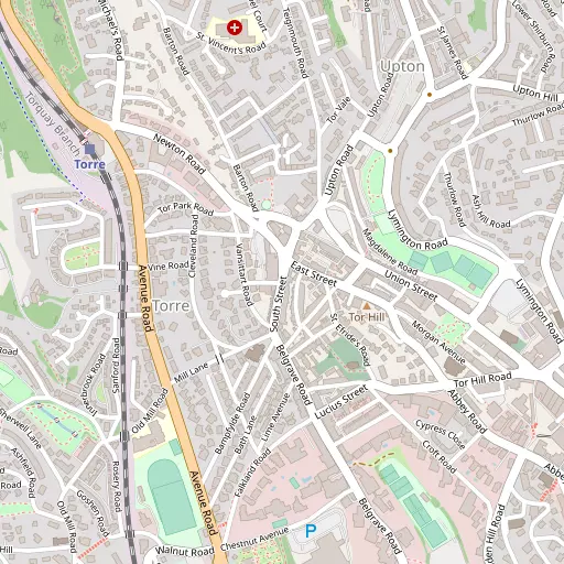
⇅
Location Summary
- Torre is a neighbourhood in Torquay
- Administrative Area: Torbay
- Ceremonial County: Torbay
- Historic County: Torbay
- Region & Country: South West / England
⇅
Nearby Towns & Cities


⇅
Nearby Localities
- UptonDistrict 617 m NE
- ChelstonDistrict 1.0 km SW
- PlainmoorDistrict 1.2 km NE
- EllacombeDistrict 1.2 km E
- CockingtonDistrict 1.4 km WSW
- ShiphayDistrict 1.6 km WNW
- St MarychurchDistrict 1.6 km NE
- HeleDistrict 1.6 km N
- LivermeadDistrict 1.7 km SSW
- BabbacombeDistrict 1.9 km ENE


⇅
Smaller Settlements
- Daccombe 3.6 km N
- North Whilborough 4.2 km WNW
- Higher Rocombe 4.3 km N
- Middle Rocombe 4.9 km N
- Lower Rocombe 5.6 km N
- Dainton 5.9 km WNW
- Lower Blagdon 6.3 km SW
- Higher Blagdon 6.4 km WSW
- Netherton 7.0 km NNW
- Two Mile Oak Cross 7.1 km WNW

⇅
Other places with this name
- Torre, Somerset76.7 km N
⇅
Beaches
- Corbyn's Beach1.1 km S
- Livermead Sands1.5 km S
- Torre Abbey Sands961 m SSE

⇅
Parks
- Palm Cross Green28.2 km WSW
- Pennsylvania Park29.8 km N
- Pleasure Grounds43.6 km NW
- The Lawn13.3 km NNE

⇅
Woods
- Daison Wood1.4 km NNE
- Markham Plantation1.3 km WNW
- Shiphay Plantation763 m WNW
- Thornhill Brake1.4 km SW
⇅
Hills
- Chapel Hill762 m NW
- Stantaway Hill691 m N
- Stentiford Hill991 m ESE
- Tor Hill194 m ESE
⇅
Lakes
- Aptor Pool5.4 km WSW
- Bickley Pond4.8 km WNW
- Mill Pool9.4 km SW
- Zitherixon Clay Works9.2 km NNW
⇅
Waterfalls
- Becka Falls21.4 km NW
- Broad Falls25.5 km W
- Horseshoe Falls20.6 km WNW

⇅
Headlands
- Black Head3.3 km E
- Watcombe Head3.5 km NNE
⇅
Islands
- Ore Stone5.1 km ESE
- Thatcher Rock4.0 km ESE
⇅
Wetlands
- Petit Tor Point2.6 km NE
- Devil's Point2.8 km E
- Netherton Point7.8 km NNW
⇅
Health Services
- Mount Stuart HospitalHospital 564 m N
- Torbay HospitalHospital 1.6 km NW
- The Warberries Nursing HomeMedical 1.7 km ESE
- Mount TryonMedical 1.8 km E
⇅
Education
- Cockington Community Primary SchoolSchool 436 m SW
- Upton St James Church of England Primary SchoolSchool 639 m NE
- South Devon College Brunel CentreUniversity 7.7 km NNW
⇅
Railway Stations
- Torquay994 m SSW
- Paignton4.3 km SSW
⇅
Bus Stations
- Kingsbridge Bus Station26.7 km SW
- Exeter Bus Station28.5 km N
⇅
Coach Stations
- Torquay Coach Station526 m NNE
- Plymouth Coach Station44.1 km WSW
⇅
Ferry Terminals
- Greenway Quay10.4 km SSW
- Kingswear Hoodown12.5 km S
⇅
Airports
- Exeter Airport30.8 km NNE
- Plymouth City Airport40.6 km W
⇅
Airfields
- Bolt Head Airfield32.9 km SW
- Farway Common Airfield39.1 km NE
⇅
Heliports
- Lake Heliport80.1 km NW
- Hartland Heliport91.9 km NW
⇅
Harbours
- New Harbour1.5 km SE
- Old Harbour1.5 km SE
