
Wilmington
About Wilmington
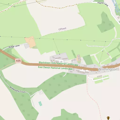
Wilmington sits within Devon. Places nearby include Offwell only 1.6 km West South West, Monkton just 3.8 km North North West, Dalwood around 4.1 km East, Northleigh just 4.2 km South South West and Shute just 5.0 km East South East. Other rural localities include Widworthy, Colwell, Mount Pleasant and Cotleigh.
You may notice something interesting if you explore one of the nearby places.
All information is drawn from OS, ONS and OSM under open licence, reflecting the best available public data.
⇅
Local Map
⇅
Location Summary
- Wilmington is located in Devon
- Administrative Area: Devon
- Ceremonial County: Devon
- Historic County: Devon
- Region & Country: South West / England
⇅
Nearby Towns & Cities


⇅
Nearby Localities
- OffwellVillage 1.6 km WSW
- MonktonVillage 3.8 km NNW
- DalwoodVillage 4.1 km E
- NorthleighVillage 4.2 km SSW
- ShuteVillage 5.0 km ESE
- LittletownDistrict 5.1 km W
- Combe RaleighVillage 5.5 km WNW
- StocklandVillage 5.9 km NE
- HeathparkDistrict 5.9 km W
- KilmingtonVillage 6.3 km ESE


⇅
Smaller Settlements
- Widworthy 858 m SE
- Colwell 1.8 km SW
- Mount Pleasant 2.2 km W
- Cotleigh 2.2 km NNW
- Ham 3.2 km ENE
- Millhayes 4.5 km NE
- Church Green 5.1 km SW
- Farway 5.2 km SSW
- Seaton Junction 5.2 km SE
- Wick 5.6 km NW


⇅
Other places with this name
- Wilmington, Bath and North East Somerset79.0 km NE
- Wilmington, East Sussex 233.0 km E
- Wilmington, Kent 242.6 km ENE
- Wilmington, City of Kingston upon Hull 380.6 km NNE

⇅
Beaches
- Branscombe Beach12.1 km S
- Pound's Pool Beach12.0 km S
- Seaton Beach10.7 km SSE

⇅
Parks
- Pennsylvania Park28.7 km WSW
- Pleasure Grounds61.7 km W
- The Lawn33.9 km SW
- Yargrass Green56.5 km NE
⇅
Woods
- Ash Copse1.3 km NNE
- Kennel Copse1.2 km ENE
- Peaty Moor1.2 km ENE
- The Belt720 m SW
⇅
Hills
- Dalwood Hill3.1 km E
- Honiton Hill3.0 km W
- Stockland Hill3.7 km NNE
- Widworthy Hill1.5 km SSE
⇅
Lakes
- Huntsman's Pool6.1 km SE
- Mill Pond6.8 km SSE
- Whitford Hole7.1 km SE
- Woodhayne Range7.1 km SE
⇅
Waterfalls
- Becka Falls48.9 km WSW
- Broad Falls64.5 km WSW
- Horseshoe Falls57.8 km WSW
⇅
Headlands
- Brandy Head20.6 km SW
- Otterton Point22.2 km SW
⇅
Islands
- Ore Stone44.7 km SSW
- Thatcher Rock45.6 km SW
⇅
Wetlands
- Stafford Marsh9.2 km SSE
- Axe Marsh9.3 km SSE
- Black Hole Marsh9.4 km SSE
⇅
Health Services
- Honiton HospitalHospital 4.4 km W
- Axminster HospitalHospital 9.1 km E
- Honiton Manor Nursing HomeMedical 5.1 km W
- SilverleighMedical 8.9 km E
⇅
Education
- Offwell Church of England Voluntary Controlled Primary SchoolSchool 1.5 km WSW
- Honiton Primary SchoolSchool 4.6 km WNW
- RowancroftUniversity 28.2 km WSW
⇅
Railway Stations
- Honiton4.4 km W
- Kingsdon7.3 km SE
⇅
Bus Stations
- Taunton Bus Station24.6 km N
- Exeter Bus Station29.1 km WSW

⇅
Coach Stations
- Torquay Coach Station45.9 km SW
- Plymouth Coach Station85.9 km WSW
⇅
Ferry Terminals
- Starcross Pier29.3 km SW
- Greenway Quay56.4 km SW
⇅
Airports
- Exeter Airport21.3 km WSW
- Cardiff Airport69.0 km NNW
⇅
Airfields
- Farway Common Airfield7.5 km SSW
- Dunkeswell Airfield10.8 km NW
⇅
Heliports
- Cardiff City Heliport74.9 km N
- Lake Heliport83.4 km WNW
⇅
Harbours
- Bridport Harbour27.0 km ESE
- Lympstone Boat Shelter27.1 km SW