
Woodcote
About Woodcote
Woodcote, in Oxfordshire, has Cray's Pond only 1.5 km South South West, Checkendon around 2.6 km East North East, Whitchurch Hill only 2.9 km South, Ipsden only 3.5 km North North West and Cleeve only 4.0 km West. Other countryside settlements include Exlade Street, Little Heath, Hook End and Goring Heath.
You may notice something interesting if you explore one of the nearby places.
All place information is taken from OS, ONS and OSM under open licence.
⇅
Local Map
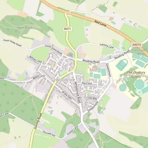
⇅
Location Summary
- Woodcote is located in Oxfordshire
- Administrative Area: Oxfordshire
- Ceremonial County: Oxfordshire
- Historic County: Oxfordshire
- Region & Country: South East / England
⇅
Nearby Towns & Cities
- Wallingford 8.5 km NNW
- Reading 11.1 km SE
- Henley-on-Thames 11.6 km E
- Watlington 13.4 km NNE
- Oxford 27.6 km NNW


⇅
Nearby Localities
- Cray's PondVillage 1.5 km SSW
- CheckendonVillage 2.6 km ENE
- Whitchurch HillVillage 2.9 km S
- IpsdenVillage 3.5 km NNW
- CleeveDistrict 4.0 km W
- Stoke RowVillage 4.0 km ENE
- GoringVillage 4.6 km WSW
- Lower Basildon Village 4.7 km SW
- South StokeVillage 4.7 km WNW
- Whitchurch-on-ThamesVillage 4.8 km SSW


⇅
Smaller Settlements
- Exlade Street 1.5 km E
- Little Heath 1.6 km SW
- Hook End 2.5 km E
- Goring Heath 2.6 km SSE
- Collins End 3.3 km SSE
- Path Hill 3.5 km SSE
- Hailey 3.7 km N
- Nuney Green 3.9 km SE
- Cane End 4.2 km SE
- Heath End 5.4 km NNE


⇅
Other places with this name
- Woodcote, Surrey 61.4 km ESE
- Woodcote, Greater London 68.7 km ESE
- Woodcote, West Sussex 69.9 km SSE
- Woodcote, Telford and Wrekin 159.9 km NNW

⇅
Beaches
- Cotswold Hills Beach63.0 km WNW
- Goatee Beach74.6 km SSW
- Weston Point74.7 km SSW
⇅
Parks
- Loop Meadow14.7 km NW
- Merton Field27.2 km NNW
- North Croft23.1 km SW
- The Common9.2 km SE

⇅
Woods
- Fox Covert865 m SW
- Lambourne's Wood906 m WSW
- Nakeds Shaw647 m S
- Upper Covert682 m S
⇅
Hills
- Catsbrain Hill2.2 km WNW
- Cocks Hill1.8 km E
- Green Hill2.3 km N
- Greenmoor Hill664 m SSE
⇅
Lakes
- Lackmore Pond1.8 km ESE
- Tidmore Pool653 m NE
- Waterfield Pond1.0 km NE
- Wimblefield Pond1.5 km NE

⇅
Waterfalls
- Neptune Waterfall39.1 km ENE
- The Cascade55.1 km N
- Tower Waterfall38.7 km ENE
⇅
Headlands
- Botany Bay Point35.6 km ESE
- Chidham Point78.9 km S
⇅
Islands
- Appletree Eyot8.0 km SSE
- Poplar Island7.9 km SSE
⇅
Wetlands
- Wargrave Marsh13.9 km E
- Midgham Marsh18.0 km SSW
- Thatcham Reed Beds20.5 km SW
⇅
Health Services
- Joyce GroveHospital 7.3 km NE
- Wallingford Community HospitalHospital 8.0 km NNW
- Huntercombe Hall Care HomeMedical 7.3 km NNE
- Benson HouseMedical 10.4 km NNW
⇅
Education
- Woodcote Primary SchoolSchool 239 m ENE
- Langtree SchoolSchool 348 m E
- University of ReadingUniversity 11.9 km SE
⇅
Railway Stations
- Goring and Streatley4.4 km WSW
- Pangbourne5.3 km SSW
⇅
Bus Stations
- High Wycombe Bus Station24.5 km ENE
- Bracknell Bus Station25.9 km ESE
⇅
Coach Stations
- High Wycombe Coachway23.2 km ENE
- Luton Airport Bus and Coach Station61.6 km NE
⇅
Ferry Terminals
- Hampton Ferry Boathouse50.9 km ESE
- Hammerton's Pier53.4 km E
⇅
Airports
- Wycombe Air Park20.3 km ENE
- Blackbushe Airport28.0 km SE
⇅
Airfields
- RAF Benson9.5 km N
- Chalgrove Airfield16.1 km N
⇅
Heliports
- The London Heliport62.2 km E
- Magpas Air Ambulance109.6 km NNE
⇅
Harbours
- Chelsea Harbour62.0 km E
- Ocean Dock74.8 km SSW