
Woodside
About Woodside
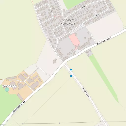
Woodside, in Central Bedfordshire, has Slip End just 604 m South East, Aley Green lying 755 m South West, Farleygreen lying 977 m North North East, Pepperstock just 1.3 km South East and Caddington around 1.5 km West North West. Other places in the surrounding countryside include Chaul End, Kensworth Lynch, Friar's Wash and West Hyde.
You may find extra local information by clicking a nearby place.
Data shown here comes from OS, ONS and OSM under open licence, using the latest public sources available.
⇅
Local Map
⇅
Location Summary
- Woodside is located in Central Bedfordshire
- Administrative Area: Central Bedfordshire
- Ceremonial County: Bedfordshire
- Historic County: Central Bedfordshire
- Region & Country: Eastern / England
⇅
Nearby Towns & Cities
- Luton 2.7 km NNE
- Dunstable 6.6 km WNW
- Harpenden 7.3 km SE
- Houghton Regis 7.6 km NW
- St Albans 13.7 km SSE


⇅
Nearby Localities
- Slip EndVillage 604 m SE
- Aley GreenVillage 755 m SW
- Farleygreen District 977 m NNE
- PepperstockVillage 1.3 km SE
- CaddingtonVillage 1.5 km WNW
- Farley Hill District 1.5 km NNE
- New Town District 2.0 km NE
- Park Town District 2.8 km NE
- Markyate Village 2.9 km SSW
- Bury Park District 3.1 km NNE


⇅
Smaller Settlements
- Chaul End 3.3 km NW
- Kensworth Lynch 3.4 km WSW
- Friar's Wash 4.0 km SSE
- West Hyde 4.1 km ESE
- Roe End 4.4 km SW
- New Mill End 4.6 km ESE
- Someries 4.6 km ENE
- Thrales End 5.2 km ESE
- Chiltern Green 6.0 km E
- Peters Green 6.6 km E


⇅
Other places with this name
Closest
- Woodside, Hertfordshire 18.5 km S
- Woodside, Hertfordshire 21.4 km SE
- Woodside, Bedford32.8 km N
- Woodside, Bracknell Forest 49.7 km SSW
- Woodside, Greater London 58.1 km SSE


Furthest away
- Woodside, Moray 666.6 km NNW
- Woodside, Aberdeen City 600.8 km N
- Woodside, Perth and Kinross 550.9 km NNW
- Woodside, Fife 515.8 km NNW
- Woodside, Fife 513.3 km NNW

⇅
Beaches
- Bell Wharf Beach83.3 km ESE
- Hadleigh Ray79.6 km ESE
- Mill Beach81.3 km E
⇅
Parks
- Balderson's Moor13.1 km S
- Bell Meadow13.2 km SSE
- Chaulden Meadow13.2 km SSW
- Seabrook Meadow13.3 km SSE
⇅
Woods
- Birchin Grove1.4 km SSE
- Heath Wood731 m NW
- Round Wood1.6 km ESE
- Top Spring1.6 km SSW
⇅
Hills
- Harps Hill2.6 km SSW
- Stipers Hill5.3 km WNW
- Warden Hill7.2 km NNE
- Winch Hill6.9 km ENE
⇅
Lakes
- Farley Pond860 m NNE
- Mill Stream6.0 km ESE
- Valentine Pond6.8 km N
- Wardown Lake4.0 km NNE
⇅
Waterfalls
- Neptune Waterfall21.7 km SSW
- The Cascade43.7 km WNW
- Tower Waterfall21.6 km SSW
⇅
Headlands
- Botany Bay Point50.9 km SSW
- Tripcock Ness53.4 km SE
⇅
Islands
- Chantry Island19.2 km SSE
- Heron Island13.7 km SSE
⇅
Wetlands
- Waterford Marsh24.2 km ESE
- Turnford Marsh32.7 km ESE
- Nazeing Marsh32.8 km ESE
⇅
Health Services
- St Mary's WingHospital 4.6 km NNW
- Harpenden HospitalHospital 6.4 km ESE
- St Marys Nursing CentreMedical 2.7 km NNE
- Alicia Nursing HomeMedical 4.9 km N
⇅
Education
- Slip End Village SchoolSchool 799 m SSE
- Caddington Village SchoolSchool 921 m WNW
- University of BedfordshireUniversity 2.9 km NE
⇅
Railway Stations
- Luton3.2 km NE
- Luton Dart3.4 km ENE
⇅
Bus Stations
- Stevenage Interchange16.7 km ENE
- Welwyn Garden City Bus Station17.3 km ESE
⇅
Coach Stations
- Luton Airport Bus and Coach Station4.9 km ENE
- Milton Keynes Coachway28.2 km NW
⇅
Ferry Terminals
- Embankment Pier44.8 km SSE
- Festival Pier45.0 km SSE
⇅
Airports
- London Luton Airport5.4 km ENE
- London Elstree Aerodrome23.8 km SSE
⇅
Airfields
- Rush Green Airfield14.0 km ENE
- Bovingdon Airfield16.4 km SSW
⇅
Heliports
- The London Heliport46.8 km SSE
- The Egerton-Smith Centre56.9 km NE
⇅
Harbours
- Chelsea Harbour46.2 km SSE
- Cutter's Dock95.3 km ESE