
Church End
About Church End
Church End sits within Central Bedfordshire. Among the nearby places are Milton Bryan around 554 m South South East, South End just 698 m South South East, Tingrith just 4.0 km East North East and Hockliffe around 4.2 km South. Other rural localities include Battlesden, Potsgrove, Speedwell, Eversholt and Water End.
You may notice something interesting if you explore one of the nearby places.
Data shown here comes from OS, ONS and OSM under open licence, using the latest public sources available.
⇅
Local Map
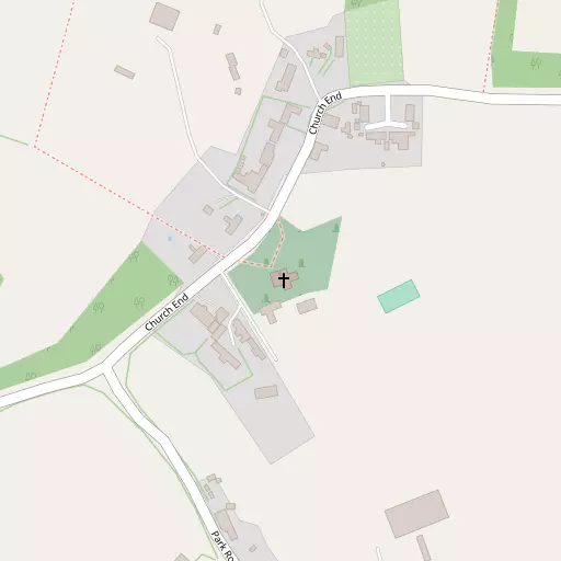
⇅
Location Summary
- Church End is located in Central Bedfordshire
- Administrative Area: Central Bedfordshire
- Ceremonial County: Bedfordshire
- Historic County: Central Bedfordshire
- Region & Country: Eastern / England
⇅
Nearby Towns & Cities
- Woburn 3.2 km NW
- Woburn Sands 6.9 km NW
- Flitwick 7.5 km ENE
- Leighton Buzzard 7.6 km SW
- Milton Keynes 14.2 km NW


⇅
Nearby Localities
- Milton BryanVillage 554 m SSE
- South EndDistrict 698 m SSE
- TingrithVillage 4.0 km ENE
- HockliffeVillage 4.2 km S
- ToddingtonVillage 4.3 km ESE
- TebworthVillage 4.7 km SSE
- RidgmontVillage 5.2 km N
- Heath and ReachVillage 5.3 km WSW
- WingfieldVillage 5.4 km SSE
- Husborne CrawleyVillage 5.7 km NNW


⇅
Smaller Settlements
- Battlesden 2.1 km SSW
- Potsgrove 2.2 km WSW
- Speedwell 2.6 km NW
- Eversholt 3.1 km NNE
- Water End 3.4 km NE
- Sheeplane 3.7 km W
- Birchmoor Green 4.0 km NW
- Wood End 4.9 km ENE
- Chalgrave 5.1 km SE
- Fancott 5.8 km ESE


⇅
Other places with this name
Closest
- Church End, Central Bedfordshire3.9 km S
- Church End, Central Bedfordshire5.6 km NNW
- Church End, Central Bedfordshire10.0 km S
- Church End, Central Bedfordshire11.4 km E
- Church End, Buckinghamshire11.6 km S

Furthest away
- Church End, Suffolk 126.3 km E
- Church End, Wiltshire 107.8 km WSW
- Church End, Gloucestershire 107.7 km W
- Church End, Lincolnshire106.2 km NNE
- Church End, Wiltshire 97.6 km WSW
⇅
Beaches
- Bell Wharf Beach97.8 km ESE
- Hadleigh Ray94.3 km ESE
- Mill Beach93.9 km ESE
⇅
Parks
- Chaulden Meadow25.3 km SSE
- Elfield Park13.0 km WNW
- Fishers Green Meadow25.5 km ESE
- The Green16.0 km NW

⇅
Woods
- Cuckoopit Spinney678 m E
- Fourteen Acre Spinney443 m ENE
- Leys Belt612 m WNW
- New Planting1.1 km SSW
⇅
Hills
- Beech Hill1.2 km NNW
- Conger Hill4.5 km ESE
- Purrets Hill2.1 km NNE
- Stonepit Hill4.8 km N
⇅
Lakes
- Greenhouse Pond1.6 km NNW
- Lower Hopgarden Pond1.5 km NNW
- New Pond1.7 km NNW
- Upper Hopgarden Pond1.4 km NNW
⇅
Waterfalls
- Neptune Waterfall32.3 km S
- The Cascade30.0 km WNW
- Tower Waterfall31.9 km S
⇅
Headlands
- Botany Bay Point61.8 km S
- Tripcock Ness69.2 km SE
⇅
Islands
- Bird Island11.2 km NNE
- Rink Islands20.4 km NNE
⇅
Wetlands
- Summer Leys33.9 km NNW
- Waterford Marsh37.9 km ESE
- Cock Marsh44.8 km SSW
⇅
Health Services
- Steppingley HospitalHospital 7.1 km NE
- St Mary's WingHospital 11.2 km SE
- Leighton Rose Care HomeMedical 6.1 km SSW
- Orchard Lodge Nursing HomeMedical 6.5 km S
⇅
Education
- Eversholt Lower SchoolSchool 2.0 km NE
- Woburn Lower SchoolSchool 3.4 km NW
- The Open UniversityUniversity 10.5 km NW
⇅
Railway Stations
- Stonehenge Works4.5 km SW
- Harlington6.4 km E
⇅
Bus Stations
- Bletchley Bus Station10.5 km WNW
- Aylesbury Bus Station22.9 km SW
⇅
Coach Stations
- Milton Keynes Coachway12.4 km NW
- Luton Airport Bus and Coach Station17.6 km SE
⇅
Ferry Terminals
- Embankment Pier60.4 km SSE
- Festival Pier60.6 km SSE
⇅
Airports
- London Luton Airport18.2 km ESE
- London Elstree Aerodrome39.0 km SSE
⇅
Airfields
- Holmbeck Farm Airfield11.6 km WSW
- Cranfield Airport11.6 km N
⇅
Heliports
- Magpas Air Ambulance51.2 km NNE
- The Egerton-Smith Centre58.3 km ENE
⇅
Harbours
- Chelsea Harbour61.5 km SSE
- Cutter's Dock110.3 km ESE