
Dawlish Warren
About Dawlish Warren
Dawlish Warren sits within Devon. Places nearby include Cockwood lying 2.0 km North, Middlewood around 2.0 km North North West, The Point lying 2.9 km North East, Starcross just 3.2 km North and Holcombe around 4.2 km South South West. Other countryside settlements include Cofton, Powderham, Ashcombe and Luton.
You might learn something new by clicking through to a nearby place.
Information is sourced from OS, ONS and OSM under open licence, using publicly available datasets.
⇅
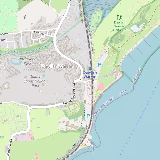
Local Map
⇅
Location Summary
- Dawlish Warren is located in Devon
- Administrative Area: Devon
- Ceremonial County: Devon
- Historic County: Devon
- Region & Country: South West / England
⇅
Nearby Towns & Cities
- Dawlish 2.5 km SW
- Exmouth 3.3 km NE
- Teignmouth 6.8 km SSW
- Budleigh Salterton 9.0 km ENE
- Exeter 15.2 km NNW


⇅
Nearby Localities
- CockwoodVillage 2.0 km N
- MiddlewoodDistrict 2.0 km NNW
- The PointDistrict 2.9 km NE
- StarcrossVillage 3.2 km N
- HolcombeVillage 4.2 km SSW
- KentonVillage 5.1 km NNW
- Withycombe RaleighDistrict 5.2 km NE
- HulhamDistrict 5.3 km NE
- LympstoneVillage 5.6 km N
- LittlehamDistrict 5.6 km ENE

⇅
Smaller Settlements
- Cofton 2.0 km NNW
- Powderham 5.9 km NNW
- Ashcombe 6.5 km W
- Luton 7.8 km WSW
- Woodmanton 8.1 km NNE
- Humber 8.1 km WSW
- Kersbrook 10.0 km ENE
- Combe 10.8 km WSW
- Lower Rocombe 10.9 km SW
- Netherton 11.3 km SW


⇅
Beaches
- Dawlish Beach1.8 km SSW
- Dawlish Warren Beach1.0 km NE
- Exmouth Beach3.0 km ENE
⇅
Parks
- Palm Cross Green41.8 km SW
- Pennsylvania Park16.5 km NNW
- Pleasure Grounds41.8 km WNW
- The Lawn2.5 km SW

⇅
Woods
- Eastdon Plantation1.5 km NNW
- Eastdon Wood1.0 km NNW
- James's Plantation1.6 km WSW
- Warren Copse1.1 km SW
⇅
Hills
- Colleywell Hill6.2 km WNW
- Easter Hill2.7 km NNW
- Exwell Hill6.9 km NNW
- Holcombe Down5.4 km SW
⇅
Lakes
- Bystock Fishponds8.0 km NE
- Merry Pool5.4 km WSW
- Mill Pond5.7 km NNE
- Ornamental Lakes6.5 km N
⇅
Waterfalls
- Becka Falls21.7 km W
- Broad Falls34.4 km WSW
- Horseshoe Falls27.9 km WSW
⇅
Headlands
- Hole Head4.2 km SSW
- The Ness7.7 km SSW
⇅
Islands
- Ore Stone15.7 km S
- Thatcher Rock16.1 km S

⇅
Wetlands
- Cockwood Marsh2.2 km NNW
- Great Bull Hill2.7 km NNE
- Little Bull Hill2.8 km NNE
⇅
Health Services
- Langdon HospitalHospital 1.8 km WNW
- Exmouth HospitalHospital 4.0 km NE
- Palm Court Nursing HomeMedical 2.6 km SW
- Sefton HallMedical 2.7 km SW
⇅
Education
- Dawlish CollegeSchool 1.8 km SW
- Gatehouse AcademySchool 1.9 km WSW
- South Devon College Brunel CentreUniversity 12.8 km SW
⇅
Railway Stations
- Dawlish2.2 km SW
- Starcross3.3 km N
⇅
Bus Stations
- Exeter Bus Station15.3 km NNW
- Kingsbridge Bus Station42.1 km SW
⇅
Coach Stations
- Torquay Coach Station15.2 km SSW
- Plymouth Coach Station55.4 km WSW
⇅
Ferry Terminals
- Starcross Pier3.2 km N
- Greenway Quay26.1 km SSW
⇅
Airports
- Exeter Airport15.4 km N
- Plymouth City Airport50.8 km WSW
⇅
Airfields
- Farway Common Airfield24.3 km NE
- Dunkeswell Airfield33.0 km NNE
⇅
Heliports
- Lake Heliport74.5 km NW
- Hartland Heliport88.7 km WNW

⇅
Harbours
- Lympstone Boat Shelter5.7 km N
- Old Harbour16.3 km SSW