
Dawlish
About Dawlish
Dawlish, in Devon, has Holcombe situated 1.8 km South South West, Dawlish Warren around 2.5 km North East, Middlewood around 3.9 km North North East, Cockwood just 4.0 km North North East and Starcross around 5.2 km North North East. Other rural communities nearby include Cofton, Ashcombe, Luton and Humber.
You might discover something new by clicking a nearby place for more local details.
The place data here is drawn from OS, ONS and OSM under open licence.
⇅
Local Map
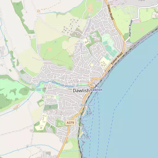
⇅
Location Summary
- Dawlish is located in Devon
- Administrative Area: Devon
- Ceremonial County: Devon
- Historic County: Devon
- Region & Country: South West / England
⇅
Nearby Towns & Cities
- Teignmouth 4.4 km SSW
- Exmouth 5.7 km NE
- Chudleigh 9.6 km WNW
- Kingsteignton 9.8 km WSW
- Exeter 16.3 km NNW


⇅
Nearby Localities
- HolcombeVillage 1.8 km SSW
- Dawlish WarrenVillage 2.5 km NE
- MiddlewoodDistrict 3.9 km NNE
- CockwoodVillage 4.0 km NNE
- StarcrossVillage 5.2 km NNE
- The PointDistrict 5.4 km NE
- ShaldonVillage 5.4 km SSW
- RingmoreDistrict 6.0 km SW
- BishopsteigntonVillage 6.0 km WSW
- KentonVillage 6.5 km N


⇅
Smaller Settlements
- Cofton 3.5 km N
- Ashcombe 5.4 km WNW
- Luton 5.9 km W
- Humber 6.0 km WSW
- Powderham 7.5 km N
- Lower Rocombe 8.4 km SW
- Combe 8.7 km W
- Netherton 8.8 km SW
- Middle Rocombe 9.0 km SSW
- Higher Rocombe 9.3 km SSW

⇅
Beaches
- Dawlish Beach814 m ENE
- Dawlish Warren Beach3.5 km NE
- Holcombe Beach2.3 km S


⇅
Parks
- Palm Cross Green39.4 km SW
- Pennsylvania Park17.7 km NNW
- Pleasure Grounds40.9 km WNW
- The Lawn126 m SSE

⇅
Woods
- Elm Grove Plantation771 m NNE
- James's Plantation950 m NNE
- Oaklands Wood1.2 km SW
- Warren Copse1.3 km NE
⇅
Hills
- Easter Hill4.3 km N
- Holcombe Down3.0 km SW
- Little Haldon4.7 km WSW
- Rocky Hill5.5 km W
⇅
Lakes
- Higher Water8.7 km W
- Merry Pool3.5 km W
- Mill Pond7.9 km NNE
- Ornamental Lakes8.6 km NNE
⇅
Waterfalls
- Becka Falls20.1 km W
- Broad Falls32.2 km WSW
- Horseshoe Falls25.7 km WSW
⇅
Headlands
- Hole Head2.1 km S
- The Ness5.3 km SSW
⇅
Islands
- Ore Stone13.9 km S
- Thatcher Rock14.1 km S
⇅
Wetlands
- Cockwood Marsh3.8 km N
- Great Bull Hill5.0 km NNE
- The Point5.0 km SSW
⇅
Health Services
- Langdon HospitalHospital 2.1 km N
- Teignmouth HospitalHospital 4.7 km SW
- Sefton HallMedical 254 m S
- Palm Court Nursing HomeMedical 371 m SE

⇅
Education
- Oakwood Specialist CollegeSchool 446 m NE
- Dawlish CollegeSchool 644 m ENE
- South Devon College Brunel CentreUniversity 10.4 km WSW
⇅
Railway Stations
- Dawlish Warren2.6 km NE
- Teignmouth4.1 km SSW
⇅
Bus Stations
- Exeter Bus Station16.5 km NNW
- Kingsbridge Bus Station39.7 km SSW
⇅
Coach Stations
- Torquay Coach Station12.9 km SSW
- Plymouth Coach Station53.1 km WSW
⇅
Ferry Terminals
- Starcross Pier5.3 km NNE
- Greenway Quay23.8 km SSW
⇅
Airports
- Exeter Airport17.5 km NNE
- Plymouth City Airport48.6 km WSW
⇅
Airfields
- Farway Common Airfield26.7 km NE
- Dunkeswell Airfield35.4 km NNE
⇅
Heliports
- Lake Heliport74.4 km NW
- Hartland Heliport88.2 km NW

⇅
Harbours
- Lympstone Boat Shelter7.8 km NNE
- Old Harbour14.1 km SSW